Elevation Tracker: Altitude
Screenshots


Description
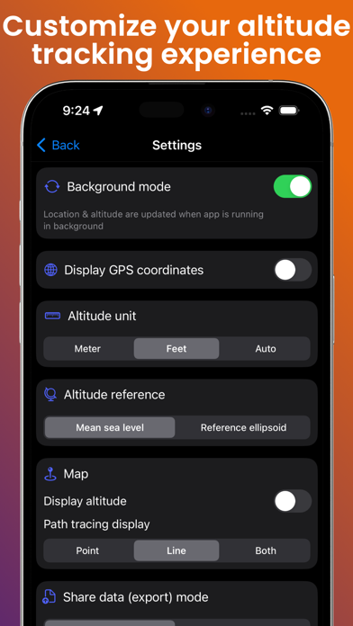
Track your altitude. Map your routes. Relive your adventures in 3D. A precise GPS altimeter and complete trip recorder for hiking, biking, skiing, paragliding, or any outdoor adventure where altitude matters. Live tracking • Real-time altitude with vertical accuracy • Distance, elevation gain & loss, average speed, stopwatch • Live Activity & Dynamic Island support — keep your stats on the Lock Screen • Background tracking, so your trip keeps recording in your pocket On the map • Switch between satellite, hybrid and standard map styles • Colored polyline along your route • Tap any point to see altitude, distance and speed at that exact spot Your trips, saved & shared • Trip history — every session stored locally on your device • Import GPX files as a ghost trace to follow a route on the map • Export your tracks as GPX (Pro) • Snapshot and share your map view with one tap 3D flyover videos (Pro) Turn your favorite hike into a cinematic 3D flyover video — your route, your camera path, your altitude stats burned in. Export to your Photos library and share it everywhere. 100% local, 100% private — no account, no cloud sync, no analytics. Your data stays on your device. Works offline. Download once, explore everywhere.
What's New
• Trip history: every session saved locally, with map snapshot and stats • Import GPX routes as a ghost trace, export your own tracks as GPX (Pro) • Turn any trip into a cinematic 3D flyover video to share (Pro)
Details
- Developer
- Florian Delaunay
- Main Category
- Navigation
- Version
- 1.6.0
- Version Release
- 2026-05-16
- Initial Release
- 2023-03-04
- Size
- 10 MB
- Age Rating
- 4+
- Price
- USD 4.99
- Languages
- EN, FR, DE, ID, ZH, ES
- Bundle ID
- lasticot.AltitudePro
- Version Rating
- ★ 4.71 (120)
- First Seen
- 2026-06-02
Metadata updated 2026-06-25
Rank History
Free · Max 90 days · Top 5 categories shown (Y-axis: rank, lower is better)
No rank history data
Free Rankings
No rankings
Paid Rankings
Competitive Benchmark — Navigation Top 10
What it takes to beat this app — comparison with the category's top apps. The orange row is the current app.
| # | App | Price | Rating | Ratings | Langs | Last Update |
|---|---|---|---|---|---|---|
| 1 | MilGPS | USD 12.99 | ★ 4.83 | 5,497 | 1 | 2026-06-20 |
| 2 | Solocator - GPS Field Camera | USD 0.99 | ★ 4.26 | 411 | 1 | 2026-04-04 |
| 3 | Blitzer.de PRO | USD 0.49 | ★ 4.33 | 21 | 11 | 2026-02-04 |
| 4 | Land Nav Assistant | USD 2.99 | ★ 4.48 | 73 | 1 | 2019-04-08 |
| 5 | Sun Seeker - Sunlight Tracker | USD 11.99 | ★ 4.84 | 12,754 | 5 | 2026-06-13 |
| 6 | Sporty's E6B Flight Computer | USD 9.99 | ★ 4.90 | 5,269 | 1 | 2024-02-17 |
| 7 | Tactical NAV | USD 8.99 | ★ 4.37 | 320 | 1 | 2026-05-31 |
| 8 | Theodolite | USD 8.99 | ★ 4.71 | 902 | 1 | 2025-06-30 |
| 9 | Speedometer 55 Pro. GPS kit. | USD 3.99 | ★ 4.71 | 2,694 | 11 | 2026-06-08 |
| 10 | aprs.fi | USD 6.99 | ★ 4.67 | 1,123 | 21 | 2026-05-31 |
| 94 | Elevation Tracker: Altitude | USD 4.99 | ★ 4.71 | 120 | 6 | 2026-05-16 |
User Reviews
I’m in Newberry Florida, we are building an Amphitheater…needed this app 3 months ago, but thankfully I found it after deleting half a dozen others…many thanks!!
As we travel through the Rocky Mountains, it's good to keep track of the elevations. This app is great and the graphics illustrate the reality of the steep grades.
Reviews are collected only for apps with detected changes (new entries or sharp risers).