
Tactical NAV
🇰🇷 KR LocalizedScreenshots


Description
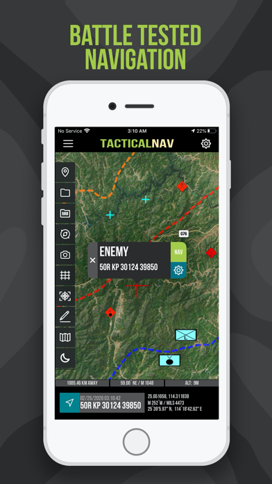
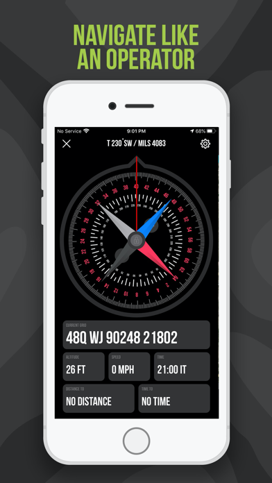
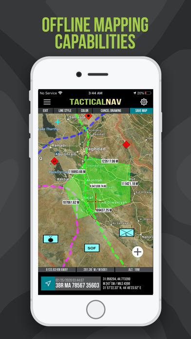
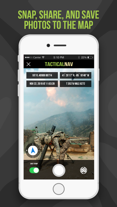
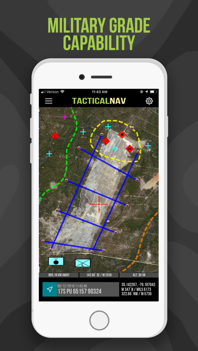
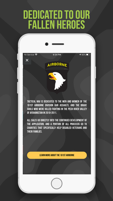
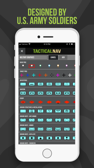
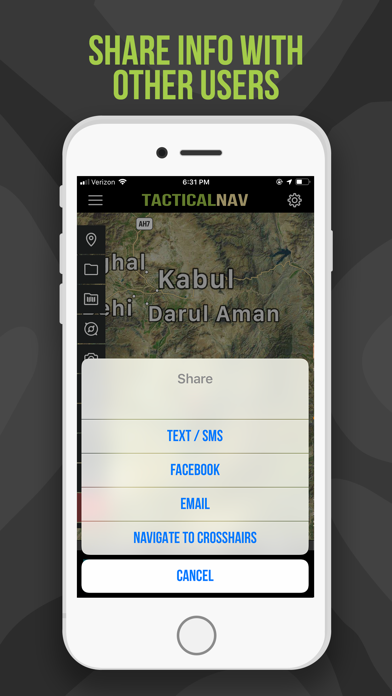
BACKGROUND: Built from the ground up in the rugged mountains of eastern Afghanistan, Tactical NAV (also known as TACNAV-X) was developed by a U.S. Army Field Artillery officer with the vision of crafting a low-cost and highly accurate mobile navigation platform tailored for the U.S. military. Tactical NAV’s journey began in the Pech and Korengal Valleys of Kunar Province, Afghanistan. U.S. Army Capt. Jonathan J. Springer, a Field Artilleryman serving as a Fire Support Officer with the 101st Airborne Division (Air Assault), embarked on the development of this tactical navigation platform immediately following the memorial services for Spc. Blair D. Thompson and Spc. Jared C. Plunk, who were killed in action on June 25, 2010. Despite initial rejections by the Department of Defense, Captain Springer remained steadfast in his mission to continue developing Tactical NAV — even to this day. His ultimate goals were (and still are) to make a positive difference for other soldiers and service members and to honor the men and women killed and wounded in battle. He used his life savings to fund and develop TACNAV-X, all with the ultimate hope of saving military lives, and helping his fellow service members in accomplishing their missions at home and abroad. Tactical NAV officially launched on the App Store on February 14, 2011. BUILT FOR ACCURACY: TACNAV-X’s performance accurately matches that of the AN/PSN-13 Defense Advanced GPS Receiver (DAGR). MISSION: Empower military service members with a highly accurate and powerful mobile navigation platform. VISION: Assist and support our nation’s service members with their mobile navigational needs and enable them to operate and win in both training and combat environments. BOTTOM LINE: Tactical NAV has successfully undergone evaluation against Nett Warrior, ATAK, BFT, and other military targeting and navigation systems. Its accuracy is within 1mm of officially approved DoD equipment. IAPs & SUBSCRIPTIONS: Currently, offline mapping mode is available as a monthly or yearly subscription, or as a one-time purchase. Drawing mode, previously an in-app purchase, is now included free for all users. All revenue generated from these features contributes to further development and updates, and a portion of the proceeds are donated to charities that specifically benefit disabled veterans. KEY FEATURES: • A military-quality precision targeting platform • Purpose-built for the individual Soldier • Offline mapping capabilities (complete usage of the app with no emission of a cellular signal) • WGS-84 standard (MGRS, UTM, BNG, and USNG coordinates) • Tactical drawing mode (useful for mission planning, building overlays, targeting, etc.) • Waypoint plotting functionality with military graphics (per FM 1-02.2) • Compass “FastLock” function for capturing quick and precise azimuths • Snap and save photographs onto the main map to increase situational awareness • Location, waypoint, and photo-sharing capabilities (via email and text) • One-button night mode function for low-light situations • Apple Watch support included for free • ‘Go to Grid’ feature for precision planning, drawing of overlays, and dropping waypoints • iOS/iPadOS native code built for austere and contested environments IMPORTANT NOTES: The Department of Defense does not endorse Tactical NAV and TACNAV-X. The app should not replace a government-issued device during life-threatening or combat operations. SUPPORT: If you have any questions about the app, please contact Jonathan Springer directly at jon@tacnavx.com. TACNAV-X VIDEO WALKTHROUGH: https://bit.ly/TACNAV-X
What's New
• Multiple bug fixes • Various app improvements • Coding for future updates • UI & performance refinements *A Note from Jonathan (Creator of Tactical NAV)* What’s up, guys. Jon here. I like to keep things real with you, so I appreciate you taking a moment to read this. As many of you know, I built this app downrange as a Field Artillery Captain in the Pech and Korengal Valleys of Afghanistan, and I’ve carried that mission with me ever since. TACNAV-X was born out of my commitment to honor the brothers we lost in 2010 and 2011. For me, this will always be more than software. It is a living tribute to their memory. They deserve nothing less. In this update, drawing mode is still completely free. It was previously an in-app purchase, but I don’t want there to be any barrier when you need it most, or for anyone to feel they’re being taken advantage of. Offline mapping remains available as a one-time purchase or subscription. That support is what allows me to pay my developers, maintain updates, and keep TACNAV alive. Nothing more. I’ll also be honest with you. I’ve been dealing with some significant health issues lately. Continuing to build and support this app is how I stay grounded and keep going. Bottom line, I appreciate the prayers, support, and well wishes during this time. If you have ideas, requests, or just want to reach out, you can always email me directly at jon@tacnavx.com. Thank you for the trust, the support, and for believing in this app, and in me. Appreciate you guys! - Jon
Details
- Developer
- TacNav Systems LLC
- Main Category
- Navigation
- Version
- 5.0.12
- Version Release
- 2026-05-31
- Initial Release
- 2011-02-14
- Size
- 49 MB
- Age Rating
- 4+
- Price
- USD 8.99
- Languages
- EN
- Bundle ID
- com.appdaddytech.tacticalnav
- Version Rating
- ★ 4.37 (320)
- First Seen
- 2026-05-28
Metadata updated 2026-07-19
Rank History
Free · Max 90 days · Top 5 categories shown (Y-axis: rank, lower is better)
No rank history data
Free Rankings
No rankings
Paid Rankings
Competitive Benchmark — Navigation Top 10
What it takes to beat this app — comparison with the category's top apps. The orange row is the current app.
| # | App | Price | Rating | Ratings | Langs | Last Update |
|---|---|---|---|---|---|---|
| 1 | MilGPS | USD 12.99 | ★ 4.83 | 5,506 | 1 | 2026-06-20 |
| 2 | Solocator - GPS Field Camera | USD 0.99 | ★ 4.27 | 413 | 1 | 2026-04-04 |
| 3 | Land Nav Assistant | USD 2.99 | ★ 4.48 | 73 | 1 | 2019-04-08 |
| 4 | Blitzer.de PRO | USD 0.49 | ★ 4.33 | 21 | 11 | 2026-06-30 |
| 5 | Sun Seeker - Sunlight Tracker | USD 11.99 | ★ 4.84 | 12,794 | 5 | 2026-07-10 |
| 6 | Sporty's E6B Flight Computer | USD 9.99 | ★ 4.90 | 5,287 | 1 | 2024-02-17 |
| 7 | Exit Strategy NYC Subway Map | USD 3.99 | ★ 4.76 | 187 | 1 | 2026-07-16 |
| 8 | Omaha Zoo - ZooMap | USD 0.99 | ★ 1.35 | 46 | 1 | 2023-09-11 |
| 9 | Find93 | USD 4.99 | ★ 3.67 | 18 | 1 | 2026-04-14 |
| 10 | Speedometer 55 Pro. GPS kit. | USD 3.99 | ★ 4.71 | 2,715 | 11 | 2026-07-05 |
| 11 | Tactical NAV | USD 8.99 | ★ 4.37 | 320 | 1 | 2026-05-31 |
User Reviews
TACNAV-X is excellent. The developer (Jon) even responded to my email from the hospital. Unbelievable. I’m super impressed!
I wanted to share my thoughts about this app because I was impressed when Jonathan (Captain Springer) took the time to respond to my email about a couple new features he's working on. This app is excellent. I've verified its accuracy, which rivals the DAGR and Falcon View, and it’s accurate to less than a meter. My mortar guys have used TacNav-X to plan and verify targets during live fire training. All on target. Pretty BA. I completely recommend this app to anyone in the military. And for infantry dudes like myself, this app is an absolute necessity.
Hi Jon, I just wanted to update my review and let you know the latest updates to the app are outstanding. As I mentioned before, I’ve been using TACNAV-X extensively for years now, and the improvements you’ve made are nothing short of impressive. Each update makes the app better and more capable, and it’s clear you’re putting real thought into how it’s used in the field. Keep up the great work, and keep making those of us at Fort Campbell proud. What really stands out is that you listen to our feedback and actually build it into the app — that matters. You’ll always have the support of those of us in 160th SOAR and 5th SFG. Thanks again, Captain. Keep it up. ~ Chief “Night Stalkers Don’t Quit!”
Apparently still hasn’t been updated to SwiftUI. Same old animations from years back. Contracting as promised. Better catch up.
Great, useful system that allows for basic plotting, useful navigation aid. Lots of features I wish it could incorporate such as maneuver graphic templates that can be easily added and dropped. This is not something that exists with the additional cost of “drawing” feature. Drawing is quirky and locks to spots, making it very difficult to make small edits. The maneuver graphics in the description photos are misleading for this. There’s no way to add simple arrows, just drawing straight lines or curved lines. I’d like there to be a feature that allows for long pressing a location in order to pull a grid or select that grid to allow quick addition of positions or graphics. It would be tremendously easier to manipulate this app with just these simple features.
Hi Jon, I’m updating my review to let you know I read your response on the latest update. Just want to say that I’m thinking of you with what you’re going through. Tactical NAV / TACNAV-X is well worth the money. Keep your head up. You’ve made the best military navigation app available. Thanks for all you continue to do. Take care man. Will
Really enjoying this app. It has three things I really wish MilGPS had: tighter MGRS grids when you zoom in (MilGPS stops at 100m grid squares, TACNAV goes to 10m), free drawing on maps, and accurate military markers! Sure, MilGPS has icons you can customize, but none of them are standard NATO markers! So you have to remember your own reasons for certain markers existing, instead of being able to rely on what already exists and is standardized. This app seems to have all the features available in other apps, while also recognizing (and providing) precision and consistency with what is established. Everything you could want and more! Highly recommend!
This app has been a life saver for my site recon. I would love to see, if possible, a feature where you can add photos from the device gallery. I am giving 5 stars because is a well thought and developed app.
Was hoping this platform would perform a little more like MilGPS. One thing that I can’t stand is that every time I go back to the application it puts me in the middle of an ocean. Needs a navigate to Create a waypoint Auto start in X location Something.
I really like this app for ATAK use. I like you can draw graphics on the app and can share them to a buddy so you are using this app for ATAK you can use it with your buddy or a team. The only thing I think it needs improvement is that a terrain map should be added to the app to see the terrain better. I find that a satellite map doesn’t show the terrain detail I would get from a terrain or Topo map.
으흠씨 5년전에 받고 좋다고 받았는데....... 뭐 ...가 ...좋은지 모르겠습니다......
It needs more functions. Distance between points ... based on real road. Map resolution is not good. When you enlarge the map in app you can not see the details. Korean map apps such as naver map and daum map is much better than this app
Reviews are collected only for apps with detected changes (new entries or sharp risers).