
Michigan Offroad Trail Map
Screenshots

Description
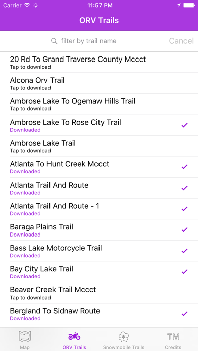
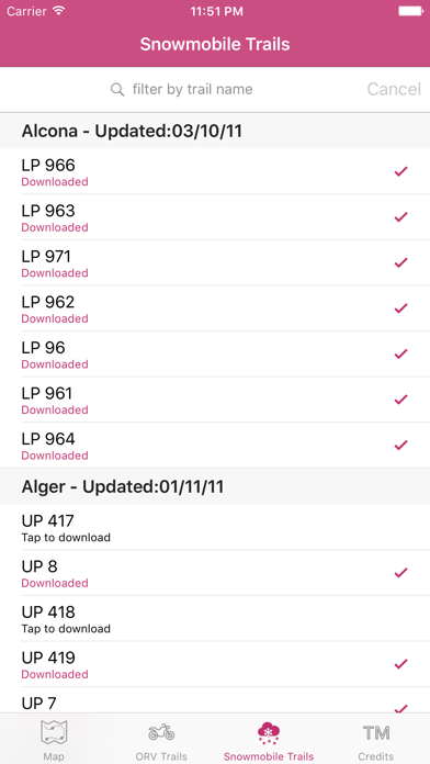
This application is your guide to the 4x4 and snowmobile trails of Northern Michigan (Lower and Upper Peninsula). Trail data is stored on the device, so if you are out of cell coverage you can still view the trail locations and your current location (underlying map data may not be rendered without data connection). Disclaimer: Trail data is from the Michigan DNR and is not guaranteed to be accurate. Some trails are seasonal and lie on private property. I am not responsible for any damage caused or liability incurred while using this application. If you like the app, leave a review. If you don't like it, still feel free to leave a review, but please try to mention your issue so that I can address it in a future update. Thanks!
What's New
The app has been updated for iOS 26 and iPadOS 26! It will look right at home with the new look and feel of the latest operating systems.
Details
- Developer
- Brendan Kirchner
- Main Category
- Navigation
- Version
- 5.3.0
- Version Release
- 2025-09-11
- Initial Release
- 2014-01-21
- Size
- 2 MB
- Age Rating
- 4+
- Price
- USD 3.99
- Languages
- EN
- Bundle ID
- com.BrendanKirchner.AtlantaTrails
- Version Rating
- ★ 3.21 (39)
- First Seen
- 2026-05-28
Metadata updated 2026-06-26
Rank History
Free · Max 90 days · Top 5 categories shown (Y-axis: rank, lower is better)
No rank history data
Free Rankings
No rankings
Paid Rankings
Competitive Benchmark — Navigation Top 10
What it takes to beat this app — comparison with the category's top apps. The orange row is the current app.
| # | App | Price | Rating | Ratings | Langs | Last Update |
|---|---|---|---|---|---|---|
| 1 | MilGPS | USD 12.99 | ★ 4.83 | 5,498 | 1 | 2026-06-20 |
| 2 | Solocator - GPS Field Camera | USD 0.99 | ★ 4.26 | 411 | 1 | 2026-04-04 |
| 3 | Land Nav Assistant | USD 2.99 | ★ 4.48 | 73 | 1 | 2019-04-08 |
| 4 | Blitzer.de PRO | USD 0.49 | ★ 4.33 | 21 | 11 | 2026-02-04 |
| 5 | Sun Seeker - Sunlight Tracker | USD 11.99 | ★ 4.84 | 12,754 | 5 | 2026-06-13 |
| 6 | Sporty's E6B Flight Computer | USD 9.99 | ★ 4.90 | 5,271 | 1 | 2024-02-17 |
| 7 | Theodolite | USD 8.99 | ★ 4.71 | 902 | 1 | 2025-06-30 |
| 8 | Tactical NAV | USD 8.99 | ★ 4.37 | 320 | 1 | 2026-05-31 |
| 9 | Speedometer 55 Pro. GPS kit. | USD 3.99 | ★ 4.71 | 2,693 | 11 | 2026-06-08 |
| 10 | Find93 | USD 4.99 | ★ 3.67 | 18 | 1 | 2026-04-14 |
| 76 | Michigan Offroad Trail Map | USD 3.99 | ★ 3.21 | 39 | 1 | 2025-09-11 |
User Reviews
Very good trail markings however the ap does not keep maps open and does not actively track to use for navigation. Is this for active navigation or just looking to see where you are?
This app is fantastic! I have been riding dirt bike trails for years with paper maps. For a trip to the UP I wanted a GPS map but didn’t want to invest in a dedicated GPS unit. This app is perfect on my iPhone. Easy to use, downloaded maps means no need for a cell signal and the maps are very accurate. My son had a minor crash and we used the app to find the fastest, most direct route back to our staging point. Will not ride without it now. Thank you for creating this helpful tool.
Zero information of where you are on the map or trail. No towns listed. It does give you the ability to delete a route. Not sure why you want to do that. You have to down load each trail map that has a number but you have no clue what area you are down loading. There is no way this person has ever used this app it’s worthless. The moss on a tree gives you more info. No clue what all the different colors or little dots mean.
This is the best Mobil Gps based app of Michigan Orv trails there is HANDS DOWN!!! You do not need service for this to work. It is based off your GPS. Only thing I wish they would add is the direction you’re currently traveling or maybe breadcrumbs other than that this app has helped me tremendously get around the trails in Michigan. Don’t hesitate and buy it.
Am I missing something? Omit says it’s compatible with my iPhone but doesn’t show any trails and the search function doesn’t do anything
I don’t see any maps? Says to filter by trail names but in order to know the names, I need to see them in the map. It’s a catch 22. Perhaps I am missing something but if I am, it’s not very user friendly then
At first, wasn’t able to download anything. Now I am able to get all of the maps. Seems like it is working well now.
Completely useless. Unable to download any of the trail maps, ORV nor snowmobile. Don’t spend the money on this app
Downloaded the app for when we’re out riding and don’t have service on our phones. The app is missing so many trails, especially around Clare and Roscommon County. I’m sure the app would work great if you’re in northern Michigan or the Upped Peninsula but for we ride its worthless.
Am I missing something? How do we know what type of trails we are looking at? Other than MCCT in the name, there seems to be no reason to the names or colors of the icons (that I can quickly determine) Example; North Branch Route or North Branch Route Track. What are they, motorcycle only, orv, side by side? What is a track? That is not verbiage that the DNR uses. I like to ride motorcycle only trails, how do I determine this? Which trails require a motorcycle to have a license plate? Example: Both Horseshoe Lake Trails have a red icon, doesn’t the north loop require a license plate? Or how does a side by side driver determine which trails he can access? I think I purchased this too quickly and, unless I’m just missing the details - which I could be, I don’t think this will be any use to me.
Reviews are collected only for apps with detected changes (new entries or sharp risers).