
Wasatch Backcountry Skiing Map
Screenshots

Description
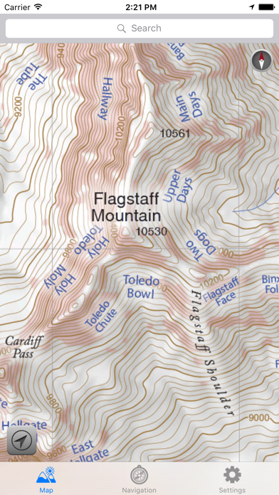
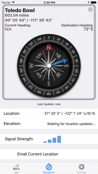
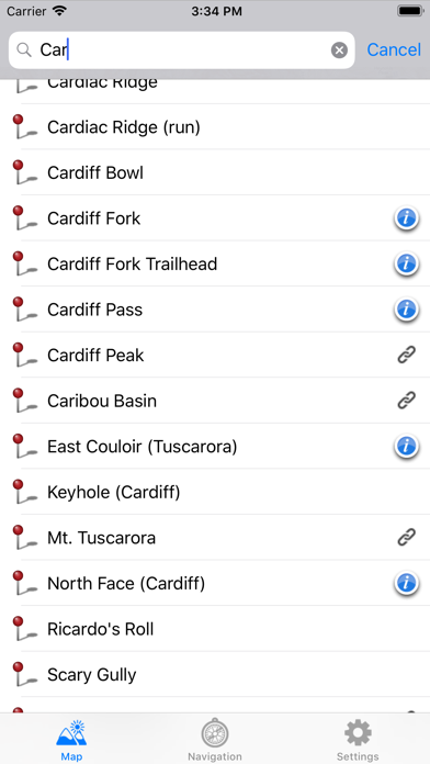
The Wasatch Backcountry Skiing Map is the iOS version of the popular paper map and website (visit WBSkiing.com). As with the other platforms, the iOS map includes an index to more than 1,000 backcountry locations in Utah’s Central Wasatch mountains. It is the must-have app for Utah hikers and backcountry travelers. With a familiar map-app interface, the Wasatch Backcountry Skiing Map accesses your device’s GPS to display your current location on a high-resolution topo map. And with only a few taps, the “destination arrow” on the integrated compass will point to your desired backcountry ski location. And with a single tap, hundreds of the locations will open the Wasatch Backcountry Skiing Guide website where you can view photographs and detailed information about the location. The app also displays your current elevation and lat/long, and will send your current location via email. And with a tap, you can display detailed information on more than 200 of the locations including skiing difficulty, skinning distance, vertical climb, parking considerations, and more. (Contrary to a posted review, you don't need cell service to use this app--you don't even need a contract with a cell service provider.) NOTICES: When navigating, the “destination arrow” points directly to the destination without regard to hazards such as avalanche paths, cliffs, and rock fall. It is your responsibility to travel in the backcountry safely.
What's New
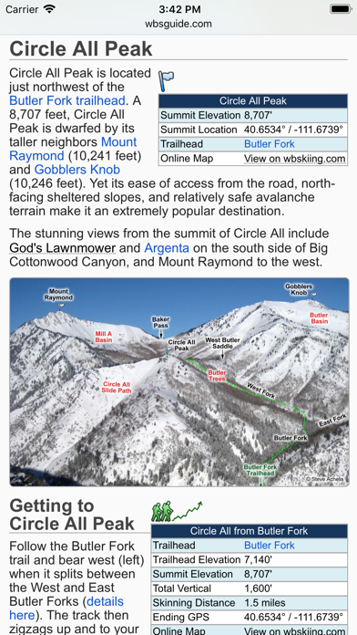
This update from Apple will improve the functionality of this app. No new features are included. Version 3.5.0 is now linked to the Wasatch Backcountry Skiing Guide. After selecting any of the hundreds of linked-locations in the app and tapping on the "Tap here for more ..." box, photographs and detailed information about the location such as skiing difficulty, skinning distance, vertical climb, altitude, aspect, and slope angle will be displayed in Safari (see screenshot). You can tap on the "WBSkiing" text in the top-left corner of Safari to return to the app. Version 3.5.0 also has a new base-map with dozens of additions and improvements. As always, it's a free upgrade.
Details
- Developer
- Iterum, LLC
- Main Category
- Navigation
- Version
- 3.5.0
- Version Release
- 2017-12-11
- Initial Release
- 2013-10-01
- Size
- 89 MB
- Age Rating
- 4+
- Price
- USD 12.99
- Languages
- EN
- Bundle ID
- Iterum-LLC.WBSkiing
- Version Rating
- ★ 4.70 (500)
- First Seen
- 2026-05-30
Metadata updated 2026-06-07
Rank History
Free · Max 90 days · Top 5 categories shown (Y-axis: rank, lower is better)
No rank history data
Free Rankings
No rankings
Paid Rankings
No rankings
More by This Developer
User Reviews
Limited map to big cottonwood canyon areas… it acted like it was the Wasatch front so I thought it would include skyline , and other backcountry areas…. It doesn’t seem to be interactive either to show current conditions
If you ride down snow in the backcountry in the Wasatch, this tool is a must.
Great UI, simple, I think the shading for avalanche areas is a bit permissive though - just because it’s not shaded does not mean you are safe. Worth the purchase.
I love how clear and easy this map is to use. I can easily take a screenshot of the map and then mark it up to send to my skiing partners. I bought the new paper map and really appreciate the higher resolution of the contour data and I wish this app had that detail. Search works well for finding locations. The iPad version doesn’t fill the entire display, not a huge deal but would be a nice fix to give me more map on my display. I kind of like the old school aesthetic of the app but it would be nice if it had some functional updates.
No data toward Midway/Heber
I can’t figure out what the purpose of this app is. It doesn’t show any BC routes and there are no terrain overlays so it’s useless unless you already know what you’re looking for. If it’s meant for navigation and route planning there are way better apps. I cannot recommend this app at all.
Easy to use and a great resource for local skiers.
Super happy with this app, and we’ll worth the price. GPS location even when out of service is accurate, and the map is easy to navigate. Elevation is also accurate enough. As others have mentioned, it would be nice to be able to access (offline) info for a specific route that you’re doing that day. It would also be interesting to see an overlay of the route you took (or are supposed to take) for certain routes, although the argument could be made that this takes the learning out of route finding and navigation (fair). All in all, I love it! The extra features would be icing on the cake. I appreciate the work that went into this!
I thought this app would show specific routes and give terrain ratings for the the approach difficulty and the descent exposure. From what I can tell it has none of those things. GAIA has basically all the information this app has, but the map layers and global topography that come with GAIA are far more extensive and more helpful. The best thing about the Wasatch backcountry app is that it shows local names for areas so you can converse with other people about a route without necessarily looking at it on the map. Not sure that’s worth the money.
Worth every fraction of a cent. This app is an invaluable resource in the backcountry.
Reviews are collected only for apps with detected changes (new entries or sharp risers).