
PeakFinder
Screenshots
Description
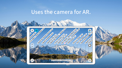
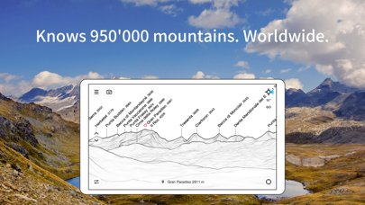
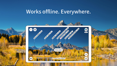
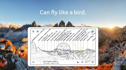
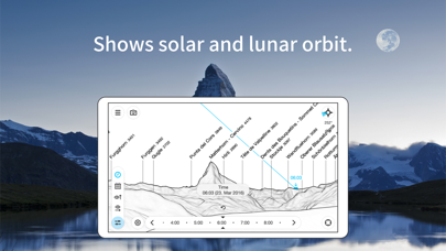
The mountains are calling! Explore more mountains than any mountaineer! PeakFinder makes it possible… and shows the names of all mountains and peaks with a 360° panorama display. This functions completely offline - and worldwide! PeakFinder knows more than 1'000'000 peaks - from Mount Everest to the little hill around the corner. ••••••••• Winner of several prizes like 'Best of AppStore', 'App of the Week', … Highly recommended by macnewsworld.com, nationalgeographic.com, smokinapps.com, outdoor-magazin.com, themetaq.com, digital-geography.com, … ••••••••• ••• Features ••• • Works offline and worldwide • Includes more than 1'000'000 peak names • Overlays the camera image with the panorama drawing • Realtime rendering of the surrounding landscapes in a range of 300km/200mil • Digital telescope to select less prominent peaks • 'Show me'-function for visible peaks • Selection of the viewpoint by GPS, the peak directory or an (online) map • Can fly like a bird from peak to peak and vertically upwards • Mark mountains and places you like • Shows the solar and lunar orbit with rise and set times • Uses compass and motion sensors • Daily updates of the peak directory • Does not contain any recurring costs. You pay only once • Is free of advertising ••• Ratings ••• Every good rating (including those following updates) makes me happy. The positive ratings and reviews make it possible for me to continue to improve the app for you. Many thanks! ••• Support ••• In case of questions, problems, mistakes, missing mountain names and ideas for future expansion, I am happy to help you. Please write to support@peakfinder.com.
What's New
Smaller optimizations and bug fixes.
Details
- Developer
- PeakFinder GmbH
- Main Category
- Travel
- Version
- 4.8.81
- Version Release
- 2026-07-06
- Initial Release
- 2010-03-12
- Size
- 42 MB
- Age Rating
- 4+
- Price
- USD 4.99
- Languages
- EN, FR, DE, IT, JA, KO and 4 more
- Bundle ID
- ch.peakfinder.peakfinder-alps
- Version Rating
- ★ 4.71 (11,528)
- First Seen
- 2026-05-28
Metadata updated 2026-07-19
Rank History
Free · Max 90 days · Top 5 categories shown (Y-axis: rank, lower is better)
No rank history data
Competitive Benchmark — Travel Top 10
What it takes to beat this app — comparison with the category's top apps. The orange row is the current app.
| # | App | Price | Rating | Ratings | Langs | Last Update |
|---|---|---|---|---|---|---|
| 1 | PeakFinder | USD 4.99 | ★ 4.71 | 11,528 | 10 | 2026-07-06 |
| 2 | LiveATC Air Radio | USD 4.99 | ★ 3.60 | 636 | 1 | 2026-01-26 |
| 3 | HappyCow - Vegan Food Near You | USD 4.99 | ★ 4.88 | 32,310 | 12 | 2026-02-18 |
| 4 | OBD Fusion | USD 9.99 | ★ 4.73 | 19,215 | 9 | 2026-07-16 |
| 5 | Roadside America | USD 3.99 | ★ 4.65 | 2,422 | 1 | 2026-07-03 |
| 6 | FAAwait | USD 0.99 | ★ 4.06 | 36 | 1 | 2025-09-09 |
| 7 | Official Freedom Trail® App | USD 9.99 | ★ 4.08 | 37 | 2 | 2026-06-30 |
| 8 | Manager for KuKirin | USD 0.99 | ★ 3.94 | 16 | 1 | 2026-07-08 |
| 9 | USFS & BLM Campgrounds | USD 0.99 | ★ 4.54 | 4,265 | 1 | 2025-07-14 |
| 10 | Fog of World | USD 30.00 | ★ 4.81 | 2,987 | 13 | 2026-05-23 |
User Reviews
使い方がよくわかりません。 位置情報とかで自動で山が見つかるわけではないので、自分で一生懸命山の形に合わせて、これかな??みたいな感じで納得する感じです 損しました
山の標高の低い地域は山名が少ないように思います。買ったけど残念です。
2017年に購入した時には、近くの山の情報が全く出てこなかったので、買って本当に損したと思いました。 8年経って、ふと、このアプリを思い出して、 『こういうのは山好きな人しか作らないだろうから、採算が合わなくても地道に情報を更新しているかもしれない』 と、もう一度インストールしてみました。 そうしたら360度山の名称から山頂の高度がぎっしり。 ああ、やっぱり、これを作ってる人たちは山が好きなのだなと思いました。 情報が画面の枠をはみ出してしまって見えない所もありますが、これも後で改善してくれると思います。 太陽の軌道が表示されていて、日の出日の入りの場所が分かります。 これはご来光などを撮影するのにとても嬉しい機能だと思います。 これからも同じ山仲間として応援しています。 頑張ってください。
I am using an iPhone 15 Pro Max, but when I try to align distant mountains in AR by zooming in, the telephoto camera doesn’t activate, resulting in a blurry screen that makes it difficult to match the mountain contours. Additionally, when I pinch out to zoom back out, the mountain contours I carefully aligned often get displaced due to the motion of my fingers.
解約の方法を教えてください。 よろしくお願いします。
自分で撮った写真で山の名前を調べてみると全く別の山の名前がでてきます。 試しにパノラマ銀座で撮った槍ヶ岳で調べてみたら常念やら大天井やらの名前が出てきます笑。 いやいや、常念に向かって歩いてる写真なんですけど笑。あの尖った槍すら認識できないとは笑。 無料版の劣化版ですね、このアプリは。 課金してまで買う必要性はないです。
登山に欠かせないアプリです。これがあると景色を見るのがさらに楽しくなる
山座同定というよりも、『あの遠くに見える山はなんだろう?』という素朴な問いに答えてくれるアプリ。(それを山座同定という)
目の前の日本百名山の名前も出てこない有料アプリ
こんな素晴らしいアプリ滅多にありません! スキーでリフト上など見晴らしの良い所からこれを使って山並み観ると、いろんな想像が膨らんで楽しいです。使い方もシンプルで美しい。
I thought this app could scan any set of mountains in a photo and identify where they were. But it’s not capable of recognizing them.
Only images...no actual image overlaid by camera
Reviews are collected only for apps with detected changes (new entries or sharp risers).