
Light Pollution Map
🇰🇷 KR LocalizedScreenshots


Description
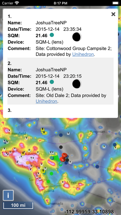
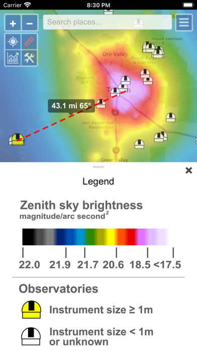
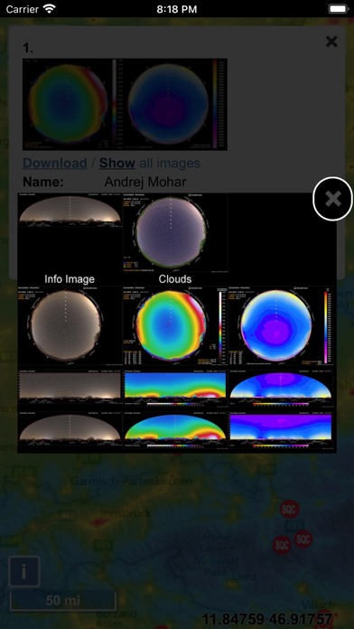
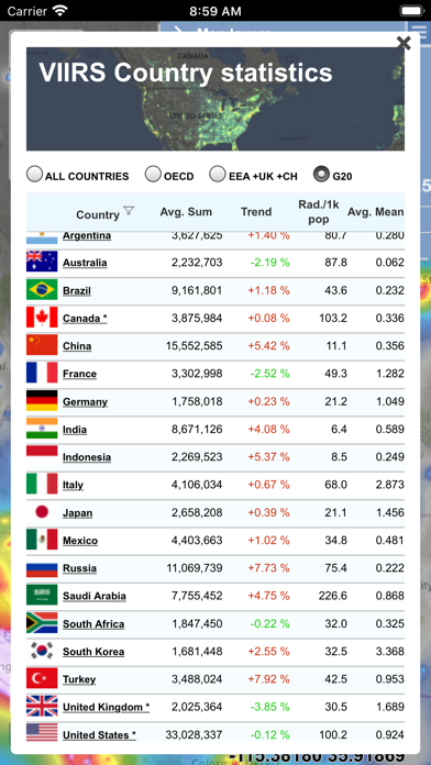
The map displays VIIRS/World Atlas/Clouds/Aurora/IAU observatories and the user SQM measurements. The primary use is to show VIIRS/DMSP data in a friendly manner, but over time it also included some other interesting overlays that concern light pollution like SQM/SQC, World Atlas 2015 zenith brightness, clouds, aurora and IAU observatories. If you have a permanent SQM reader installed you can add it to the map by sending me an e-mail. Please send comments and requests for new features via email (look under help) Functionalities: - VIIRS, Sky Brightness, World Atlas 2015, Cloud coverage and Aurora forecast layers - VIIRS and Sky Brightness layers can be displayed in color blind friendly colors - Road & Satellite base maps - Cloud animation for the last 12 hours - Get detail radiance and SQM values from layers at a click. For Sky brightness/World Atlas 2015, you also get Bortle class estimation. - SQM, SQM-L, SQC, SQM-LE, SQM readings submitted by users - International dark sky parks overlay - Submit your own SQM (L) readings - Observatories layer - Save your favorite locations - Distance measurement tool with azimuth angle report - All-sky view of light pollution with real horizon - Offline mode (Sky brightness map and a base map are saved to your device, so it will be displayed when you are offline)
What's New
- Feature filters can be now be saved (settings). Name field also supports wildcard searching for example '*town OR john*' will display 'Smalltown' and 'Johnstown'. - 'My locations' can now be saved (and edited) and restored from a file. - 'My locations' now also available as a feature overlay, so you can view them on the map. - Changing dates in the calendar widget doesn't open virtual keyboard anymore (except when you tap on hour/minute fields). - Other minor changes and bug fixes.
Details
- Developer
- Jurij Stare
- Main Category
- Navigation
- Version
- 1.1.39
- Version Release
- 2026-05-29
- Initial Release
- 2020-09-20
- Size
- 20 MB
- Age Rating
- 4+
- Price
- USD 4.99
- Languages
- EN
- Bundle ID
- info.lightpollutionmap.mobile
- Version Rating
- ★ 4.13 (46)
- First Seen
- 2026-05-28
Metadata updated 2026-07-19
Rank History
Free · Max 90 days · Top 5 categories shown (Y-axis: rank, lower is better)
No rank history data
Free Rankings
No rankings
Paid Rankings
Competitive Benchmark — Navigation Top 10
What it takes to beat this app — comparison with the category's top apps. The orange row is the current app.
| # | App | Price | Rating | Ratings | Langs | Last Update |
|---|---|---|---|---|---|---|
| 1 | MilGPS | USD 12.99 | ★ 4.83 | 5,506 | 1 | 2026-06-20 |
| 2 | Solocator - GPS Field Camera | USD 0.99 | ★ 4.27 | 413 | 1 | 2026-04-04 |
| 3 | Land Nav Assistant | USD 2.99 | ★ 4.48 | 73 | 1 | 2019-04-08 |
| 4 | Blitzer.de PRO | USD 0.49 | ★ 4.33 | 21 | 11 | 2026-06-30 |
| 5 | Sun Seeker - Sunlight Tracker | USD 11.99 | ★ 4.84 | 12,794 | 5 | 2026-07-10 |
| 6 | Sporty's E6B Flight Computer | USD 9.99 | ★ 4.90 | 5,287 | 1 | 2024-02-17 |
| 7 | Exit Strategy NYC Subway Map | USD 3.99 | ★ 4.76 | 187 | 1 | 2026-07-16 |
| 8 | Omaha Zoo - ZooMap | USD 0.99 | ★ 1.35 | 46 | 1 | 2023-09-11 |
| 9 | Find93 | USD 4.99 | ★ 3.67 | 18 | 1 | 2026-04-14 |
| 10 | Speedometer 55 Pro. GPS kit. | USD 3.99 | ★ 4.71 | 2,715 | 11 | 2026-07-05 |
| 16 | Light Pollution Map | USD 4.99 | ★ 4.13 | 46 | 1 | 2026-05-29 |
User Reviews
After the most recent update I noticed that the maps have no regional, state, or national border details which make it difficult to navigate. Please fix asap.
This tool is so important in showing how humans are changing the planet. All life depends on darkness for circadian rhythms, and this measures how much we need to return to a healthy state for flora and fauna alike.
Screen went solid white. Had to uninstall and reinstall. Now I have the position map, but not base layer - so I cannot tell what locations correspond to the colors.
Every time and day it shows same class even sky is more clear, darker and light pollution free.
I like the app but the most recent data, VIIRS 2023, is only on the website making this app useless as of now. Hopefully it will be added soon.
Jurij: Great app! Certainly a very useful tool for all kinds of things. I found it as someone had linked to it from Reddit. People like to know where to go to stargaze, or see the northern lights. Take care!
On iPad app won’t zoom or pan accurately. Just moves the map however it wants.
I’ve used the web based version for some time but thought I’d try the app. Overall it’s great. Understanding some of the values being listed and what it means for your dark sky experience takes a little leg work. I had to go and actually read part of the paper that goes along with the underlying data set. For me the salient figure would be the ratio listed whenever you click on a point in the map. This ratio is the ratio of the artificial brightness from pollution over the natural brightness of the night sky. Per the paper looking straight up anything 1% or less is about as good as you’re going to get (middle of the ocean would be 0% but 1% is about as good if not looking at the horizon). Haven’t looked at every feature so far but overall app works great but the lag to get stats when you click on a location gets tedious.
Great idea, desktop version may be better. App help text doesn’t fit on screen; map only responds erratically when I try to move location (using two fingers). Possible delay on server end?
I love this app and am optimistic they will update it to be more user-friendly soon. I’d like a user tutorial, and instead of technical labels in the overlay settings, that there were layperson labels. Also on the main map screen there are tools in the top left that have no labels so I don’t know what they do.
Reviews are collected only for apps with detected changes (new entries or sharp risers).