
Topographic Maps & Trails
Screenshots

Description
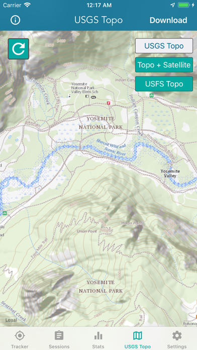
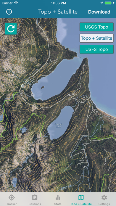
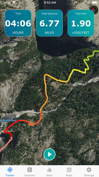
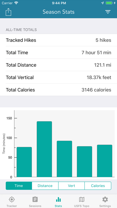
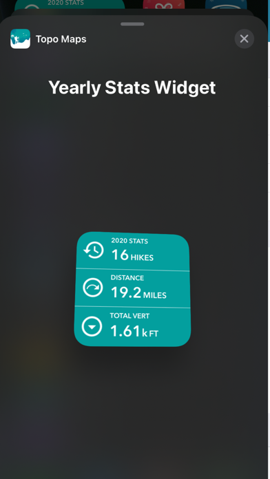
DOWNLOAD ALL MAPS FOR OFFLINE USE MAIN FEATURES INCLUDE: - USGS Topographic Maps - Satellite + Topo Maps - Hiking Tracker USGS TOPO MAP USGS Topo is a tile cache base map service that combines the most current data in The National Map (TNM), and other public-domain data, into a multi-scale topographic reference map. TOPO + SATELLITE USGS Imagery Topo is a tile cache base map of orthoimagery in The National Map and US Topo vector data. Orthoimagery data are typically high resolution images that combine the visual attributes of an aerial photograph with the spatial accuracy and reliability of a planimetric map. Data themes included are Boundaries, Geographic Names, Transportation, Contours, Hydrography, Land Cover, Shaded Relief, Trails, etc. HIKING TRACKER Now you can track all of your hiking stats! - Track total distance, vertical, time - Track calories burned - Keep track of yearly stats - Color coded tracks by elevation - Backup your hike data to iCloud - iOS 14 home screen widget Have questions? Feel free to contact me at support@lwbrandsllc.com
What's New
+ Updated the Season Stats widget for 2026 + Fixed a few minor bugs Thank you for the positive feedback!
Details
- Developer
- LW Brands, LLC
- Main Category
- Navigation
- Version
- 1.7
- Version Release
- 2026-01-02
- Initial Release
- 2018-11-02
- Size
- 23 MB
- Age Rating
- 12+
- Price
- USD 4.99
- Languages
- EN
- Bundle ID
- topographic.lwbrands
- Version Rating
- ★ 4.57 (2,810)
- First Seen
- 2026-05-30
Metadata updated 2026-07-19
Rank History
Free · Max 90 days · Top 5 categories shown (Y-axis: rank, lower is better)
No rank history data
Free Rankings
No rankings
Paid Rankings
Competitive Benchmark — Navigation Top 10
What it takes to beat this app — comparison with the category's top apps. The orange row is the current app.
| # | App | Price | Rating | Ratings | Langs | Last Update |
|---|---|---|---|---|---|---|
| 1 | MilGPS | USD 12.99 | ★ 4.83 | 5,506 | 1 | 2026-06-20 |
| 2 | Solocator - GPS Field Camera | USD 0.99 | ★ 4.27 | 413 | 1 | 2026-04-04 |
| 3 | Land Nav Assistant | USD 2.99 | ★ 4.48 | 73 | 1 | 2019-04-08 |
| 4 | Blitzer.de PRO | USD 0.49 | ★ 4.33 | 21 | 11 | 2026-06-30 |
| 5 | Sun Seeker - Sunlight Tracker | USD 11.99 | ★ 4.84 | 12,794 | 5 | 2026-07-10 |
| 6 | Sporty's E6B Flight Computer | USD 9.99 | ★ 4.90 | 5,287 | 1 | 2024-02-17 |
| 7 | Exit Strategy NYC Subway Map | USD 3.99 | ★ 4.76 | 187 | 1 | 2026-07-16 |
| 8 | Omaha Zoo - ZooMap | USD 0.99 | ★ 1.35 | 46 | 1 | 2023-09-11 |
| 9 | Find93 | USD 4.99 | ★ 3.67 | 18 | 1 | 2026-04-14 |
| 10 | Speedometer 55 Pro. GPS kit. | USD 3.99 | ★ 4.71 | 2,715 | 11 | 2026-07-05 |
| 48 | Topographic Maps & Trails | USD 4.99 | ★ 4.57 | 2,810 | 1 | 2026-01-02 |
More by This Developer
National Hurricane Center Data
Weather · ★ 4.8 (74,950)
Marine Weather Forecast Pro
Weather · ★ 4.7 (16,023)
NOAA Marine Forecast & Weather
Weather · ★ 4.7 (4,907)
Nautical Charts & Maps
Navigation · ★ 4.6 (3,768)
River Levels & Flows
Weather · ★ 4.6 (2,620)
Wildfire - Fire Map Info
Weather · ★ 4.4 (1,713)
Great Lakes Boating Weather
Weather · ★ 4.6 (1,408)
Topo Map & Hiking Tracker
Navigation · ★ 4.7 (1,357)
User Reviews
It needs a search feature to speed up planning
Haven’t really used it yet but it looks awesome
meh, downloading offline maps is annoying, can’t just draw a box around a region and download, they have some janky system where you have to zoom in and pan and scan everywhere.. so if you don’t pan and scan and zoom in on a particular tile it wont save. Obviously not an Outdoorsy Off Grid person. Waste of $$$
I used to have “trails” app until they were no longer available I had to look hard to find a similar app and after trying and deleting many apps I found this. So far it’s great Thanks to developers
Except unlike Google Earth, I can’t just enter in an address. I have to find my way there. I got this info on google earth b4 but can’t figure out how to do it again.
I love this app. The maps and GPS tracking is better than GM, or any other app I’ve tried.
USFS Maps are not as expected, no trail maps, not the online version of USFS Maps. Disappointed. Wish I could get my $5 back
These maps are hard to read and are not USGS 7.5 minute topographic maps. False advertising.
Map does not show detailed i
There are many apps with similar goals and I own some and tried many of them. This is a very good one, simple to use intuitive in controls, etc. What make is stand out head and shoulders above others is the system of prompts and user guidance that pop on the screen, the device memory use and user friendliness. I wish ALL APPS ON MY iPhone were made by this apps author! Wish list: Integration with iPhone health app. If it is already integrated, I did not see it.
Reviews are collected only for apps with detected changes (new entries or sharp risers).