
스크린샷

설명
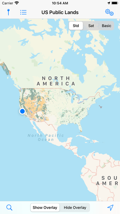
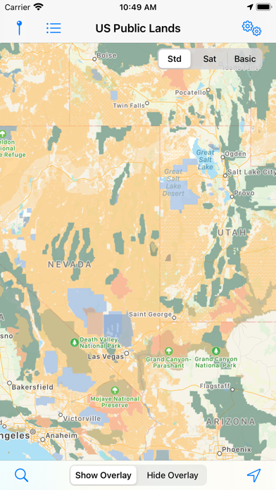
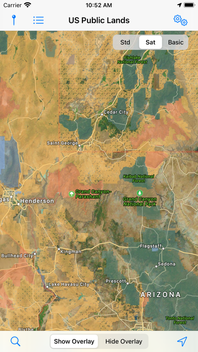
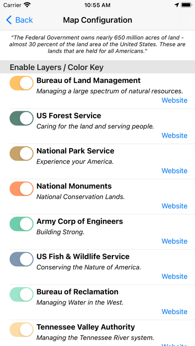
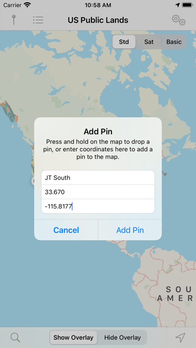
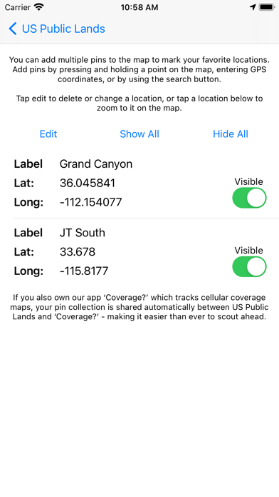
The US Federal Governments owns nearly 650 million acres of land - almost 30 percent of the land area of the United States. These are lands that are held for all Americans. US Public Lands allows you to quickly retrieve the boundaries of these properties without carrying physical maps, books, or digging deep online. Included in the app are on-device (fully works offline), individually selectable & beautifully colored map layers for most of the properties administered by the federal government: - Bureau of Land Management (BLM) - US Forest Service (FS) - National Park Service (NPS) - Army Corp of Engineers (ACOE) - US Fish & Wildlife Service - Bureau of Reclamation - Tennessee Valley Authority - Department of Defense (military bases & installations) - Other (National Laboratories, Test Sites, etc...) Key Benefits & Features - Know which US agency owns and operates the land you're on or are heading to. Use the "Layers" icon to select which agencies you want displayed to create your own custom map. (Hint, the toggles are color coded to the color each layer is displayed in.) - Links are provided to each agency's website within the app, so that you can further your research as to what land use rules apply for each public land type - such as permits, fees, activities allowed, and limits of stay. - Map layers are stored on device - no internet connection required. - Be sure to turn on the 'Basic' base map to see the US Public Land labels for each land area. This base map layer is also stored entirely on your device, and can be utilized if you do not have an internet connection or would like to conserve bandwidth. - If you have an internet connection (or have cached them before going out of signal), you can utilize the built in Apple Maps and satellite view maps as the base layer underneath the public land overlays. - A boondocker's assistant - While US Public Lands is not specifically a camp site locator and does not have a database of specific sites, by turning on the satellite view map, you can better scout out trails, roads and signs of dispersed camping locations within the boundaries of the public land resources. - Quickly toggle between 'Show' and 'Hide' via the "Map" icon to more clearly see satellite images below. - If you have GPS access on your device, click the 'Locate Me' icon to show your present location - know what type of land you're on right now! - Built in search tool locates anything on device maps supports (requires internet access) - including cities, states, zip codes, addresses and points of interest. A pin is dropped at the search location. Thank you to the Protected Area Database (PAD-US) of the U.S. Geological Survey for providing the public domain raw map data that we’ve been able to utilize to create this interactive overlayable mapping & navigation tool. We will update our maps in the future to stay in sync with improvements to this data set. Please note, the USGS PAD-US database contains the “most up-to-date aggregation of Federal lands and waters” available, but this database is still evolving and some locations may not be listed and others may not have precisely accurate boundaries. Resolution across the nation may vary. And always remember - there may be private unmapped inholdings within any public lands - so always pay attention to local signage, indications, and information. The US Public Lands app should only be used as an overview, and you should always confirm more precise details by consulting local field offices, administration websites, and other resources. Do not solely rely on this app for determining if you are on public or private land.
새로운 소식
Updated maps to PADUS 4.1 Added ability to backup and restore pins. Added export feature so that pins can be imported into mapping software.
상세 정보
- 개발사
- Two Steps Beyond
- 주 카테고리
- Travel
- 현재 버전
- 2026.3
- 버전 출시일
- 2026-04-01
- 최초 출시일
- 2014-04-11
- 용량
- 184 MB
- 연령 등급
- 4+
- 가격
- USD 3.99
- 언어
- EN
- 번들 ID
- com.twostepsbeyond.public-lands
- 현재 버전 평점
- ★ 4.46 (745)
- 첫 수집
- 2026-05-28
메타데이터 갱신 2026-07-19
순위 히스토리
무료 기준 · 최대 90일 · 상위 5개 카테고리 표시 (Y축: 순위, 낮을수록 상위)
순위 히스토리 데이터가 없습니다
무료 순위
순위 없음
유료 순위
경쟁 벤치마크 — Travel Top 10
이 앱을 이기려면 무엇이 필요한가 — 같은 카테고리 상위권과의 비교입니다. 주황색 행이 현재 앱입니다.
| # | 앱 | 가격 | 평점 | 리뷰 수 | 언어 | 최근 업데이트 |
|---|---|---|---|---|---|---|
| 1 | PeakFinder | USD 4.99 | ★ 4.71 | 11,528 | 10 | 2026-07-06 |
| 2 | LiveATC Air Radio | USD 4.99 | ★ 3.60 | 636 | 1 | 2026-01-26 |
| 3 | HappyCow - Vegan Food Near You | USD 4.99 | ★ 4.88 | 32,310 | 12 | 2026-02-18 |
| 4 | OBD Fusion | USD 9.99 | ★ 4.73 | 19,215 | 9 | 2026-07-16 |
| 5 | Roadside America | USD 3.99 | ★ 4.65 | 2,422 | 1 | 2026-07-03 |
| 6 | FAAwait | USD 0.99 | ★ 4.06 | 36 | 1 | 2025-09-09 |
| 7 | Official Freedom Trail® App | USD 9.99 | ★ 4.08 | 37 | 2 | 2026-06-30 |
| 8 | Manager for KuKirin | USD 0.99 | ★ 3.94 | 16 | 1 | 2026-07-08 |
| 9 | USFS & BLM Campgrounds | USD 0.99 | ★ 4.54 | 4,265 | 1 | 2025-07-14 |
| 10 | Fog of World | USD 30.00 | ★ 4.81 | 2,987 | 13 | 2026-05-23 |
| 21 | US Public Lands | USD 3.99 | ★ 4.46 | 745 | 1 | 2026-04-01 |
이 개발사의 다른 앱
유저 리뷰
I’m new to dispersed camping and used US public lands to find national forest land to camp on. A few hours into camping, the owners of the land show up and tell me it is private property. Later, I check the my camping location on 2 other apps (onX offroad and regrid). Those other apps show me the CORRECT BORDER and that I am in fact on private land. This app is trash, DO NOT USE IT.
You can’t copy the latitude-longitude of a spot you’re interested in to paste into Google maps. This is extremely inconvenient. It really only works for checking if you are, in fact, on public land already and is of little help finding where to go.
This app will present you with a map that outlines public lands, assuming that you can figure out which shade of color or very limited symbology a particular spot may correlate with. It does little or nothing to provide even the most basic information on what the public land shown on the map is (name, etc.), let alone whether there is any access to it. I have rarely found it useful as a result.
It’s difficult to use this app. I’m simply trying to identify land with dispersed camping, are Fish and Wildlife holdings displayed here because they have that? Also a lot of back and forth and guessing to use the color key that identifies the type of land that is overlaid. Quite regret this purchase.
Wanted an app like this. It's close. The color overlay is ok except green areas because the default map color is green. Must squint and guess. Should let you tap to get management info about a the location. Maybe change default map color or allow configuration of overlay/map colors. Yes, you can choose "basic map" with white default color to help, but lose roads and whatnot. You can zoom in but some areas have fuzzy, gradient borders. Shouldn't the GIS data be very clear about boundaries?
I purchased this app to help me find legal shooting locations on national forest land. Unfortunately, the detail and accuracy of the maps are not good enough for me to rely upon. I live next to national forest land, but the app shows that my house and all the homes around me are on national forest land, which they are not. Hopefully over time the maps will get better. Nevertheless, the app is well done. I just think it needs a better database to draw upon. I would like to see the national forest system put out more detailed information for app developers to draw upon.
In using this app for the last year it has become very clear that the maps within the app do not accurately list or show privately owned lands within BLM and USFS boundaries.
This app is just a rehash of low resolution publicly available info but once you sign up for it the subscription doesn’t show up to be cancelled but you keep getting charged. This “feature” is obviously where they focused their efforts.
Great app! Comes in very useful. I wonder though if/when state owned lands will be added?
We live in a rural area that is a mix of private and public land. I bought this app hoping it would let me know where it’s safe to hike without trespassing, but it doesn’t even show the private property that I already know of. It shows half of the neighboring subdivision and all of the private land near a local reservoir as part of the national forest. I deleted it almost as soon as I bought it because I knew it wouldn’t be useful at all here. Only consider this app if you need it in the most general sense; do not trust it if you are out on the land and want accurate boundaries.
변동(신규 진입·급상승) 감지된 앱에 한해 Apple RSS 최신 리뷰를 수집합니다.