스크린샷
설명
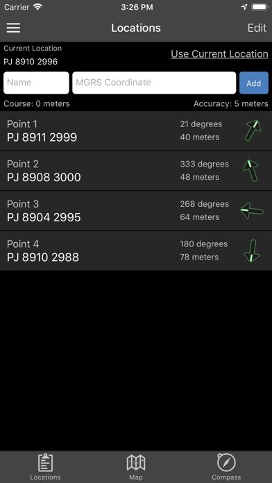
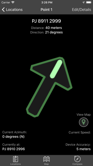
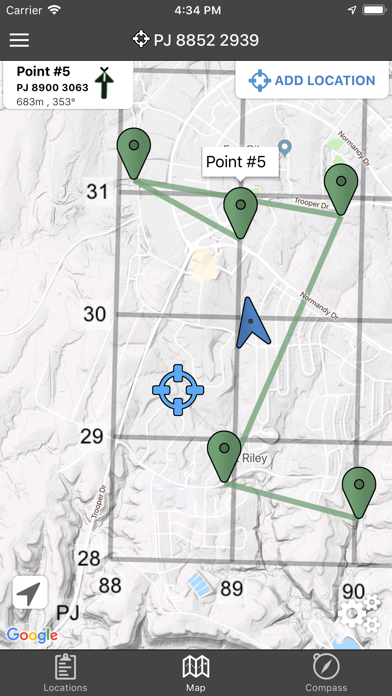
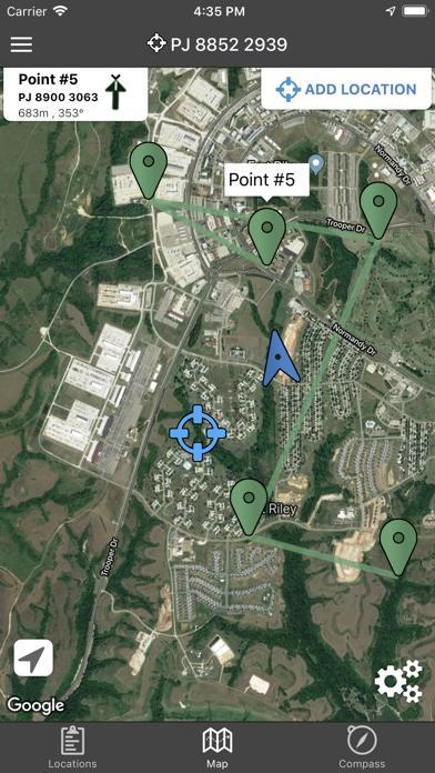
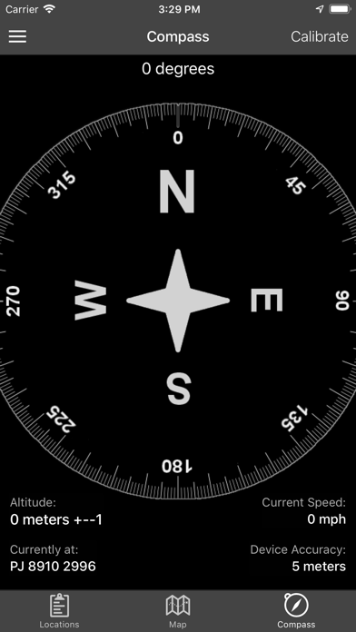
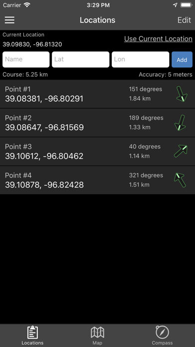
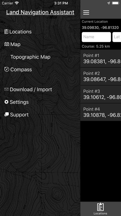
Land Nav Assistant accepts MGRS (Military Grid) or Latitude / Longitude coordinates and visually navigates you to each point. This app was designed with Army, Marine, and other military personnel in mind. Use it to correct your Land Nav technique by analyzing your pace count and tendency to veer left and right. Available Input: 8 digit MGRS, 10 digit MGRS, Lat/Lon decimal, Lat/Lon dms, and map input. Angles: degrees or mils Distance: meters/km or feet/miles Speed: kph or mph Use the simple arrow interface or map to direct you to your locations. Your distance, direction, speed, and bearing are shown as you navigate. Long-tap anywhere on the map to get the coordinate for that location. Easily add locations via the Map interface. Plan your course by ordering points, or use the course optimization tool which will help you calculate the shortest path possible! Get distance/direction between two points by tapping the path drawn between them. Satellite, Terrain, Road, and basic Topographic maps show you, your locations, and lets you enter in new ones. Overlay a 1000m or 100m MGRS grid anywhere on the map. Displays distance/direction from your currentl location to all points, or between any two points. Download your Locations as a spreadsheet to save anywhere, or to share with anyone you choose. Import a large set of locations via the web import utility, available at: https://www.gammonapplications.com/land-navigation-services/import This app uses the Military Grid Reference System (MGRS) and Latitude / Longitude. Choose to display your locations as MGRS 10-digit, MGRS 8-digit, or LatLon Decimal. D:M:S can be input in the format DD:MM:SS followed by the appropriate direction (NSWE). Default direction is N, W. DO NOT use this application while learning Land Navigation. Land Navigation is a valuable skill, and should be mastered before using this application. Do not rely solely on this application for navigation, especially when lost. Always be aware of your surroundings.
새로운 소식
Draw MGRS Grid Overlays anywhere on the map (1000m, 100m) iOS 12 Optimization Screen improvements for iPhone X, XS, and XR
상세 정보
- 개발사
- Gammon Applications, LLC
- 주 카테고리
- Navigation
- 현재 버전
- 2.2
- 버전 출시일
- 2019-04-08
- 최초 출시일
- 2012-05-18
- 용량
- 36 MB
- 연령 등급
- 4+
- 가격
- USD 2.99
- 언어
- EN
- 번들 ID
- com.gammonapps.landnav
- 현재 버전 평점
- ★ 4.48 (73)
- 첫 수집
- 2026-05-28
메타데이터 갱신 2026-07-19
순위 히스토리
무료 기준 · 최대 90일 · 상위 5개 카테고리 표시 (Y축: 순위, 낮을수록 상위)
순위 히스토리 데이터가 없습니다
무료 순위
순위 없음
유료 순위
경쟁 벤치마크 — Navigation Top 10
이 앱을 이기려면 무엇이 필요한가 — 같은 카테고리 상위권과의 비교입니다. 주황색 행이 현재 앱입니다.
| # | 앱 | 가격 | 평점 | 리뷰 수 | 언어 | 최근 업데이트 |
|---|---|---|---|---|---|---|
| 1 | MilGPS | USD 12.99 | ★ 4.83 | 5,506 | 1 | 2026-06-20 |
| 2 | Solocator - GPS Field Camera | USD 0.99 | ★ 4.27 | 413 | 1 | 2026-04-04 |
| 3 | Land Nav Assistant | USD 2.99 | ★ 4.48 | 73 | 1 | 2019-04-08 |
| 4 | Blitzer.de PRO | USD 0.49 | ★ 4.33 | 21 | 11 | 2026-06-30 |
| 5 | Sun Seeker - Sunlight Tracker | USD 11.99 | ★ 4.84 | 12,794 | 5 | 2026-07-10 |
| 6 | Sporty's E6B Flight Computer | USD 9.99 | ★ 4.90 | 5,287 | 1 | 2024-02-17 |
| 7 | Exit Strategy NYC Subway Map | USD 3.99 | ★ 4.76 | 187 | 1 | 2026-07-16 |
| 8 | Omaha Zoo - ZooMap | USD 0.99 | ★ 1.35 | 46 | 1 | 2023-09-11 |
| 9 | Find93 | USD 4.99 | ★ 3.67 | 18 | 1 | 2026-04-14 |
| 10 | Speedometer 55 Pro. GPS kit. | USD 3.99 | ★ 4.71 | 2,715 | 11 | 2026-07-05 |
유저 리뷰
Terrible app, very outdated and doesn’t work
Reliable app that works even with little to no network once downloaded. I wish I could save routes and create new ones.
Great app. Helped me a lot with confirming my points. I do wish there was a smart watch (Apple Watch/ android watch) adaptation!!! Developers if you can, please 😂
I get the 1.99 cost for this app,but what was the extra 42.39 for,if you are going to charge this for an app put the full cost up front and not try to rip someone off
This app is awesome, brings you right where you need to go. I downloaded other apps like MIL GPS that cost $12 and this one is much better for 1/6 the cost. Highly recommend!
The application is perfect for training, with integration of satellite imagery it makes land nav a breeze. Needs Apple Watch integration to make it the perfect app for all land nave needs.
Crashes constantly, not useful.
This app would be a 5 stars if the developer adds the Apple Watch functionality to the app. Looking at my phone every time makes the whole event a bit clunky. I should be able to start the app on my phone and then sync it to my watch to me the whole navigation easier. I would pay extra just to have that functionality. I hope the developers hear me out
This is hands down the best app to use to cheat durning land nav as a private helped me sham out and turned what would have taken me 4 hours into an hour long endeavor
Works great on the red diamond course.
변동(신규 진입·급상승) 감지된 앱에 한해 Apple RSS 최신 리뷰를 수집합니다.