
Maps 3D PRO - Outdoor GPS
🇰🇷 KR 현지화Maps 3D PRO - Hike & Bike
movingworld GmbH스크린샷
설명
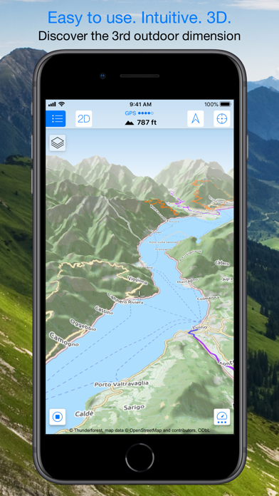
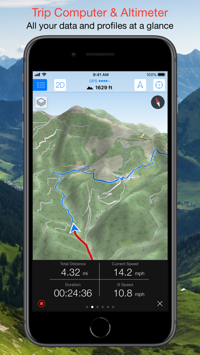
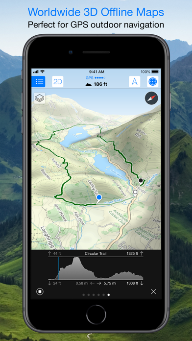
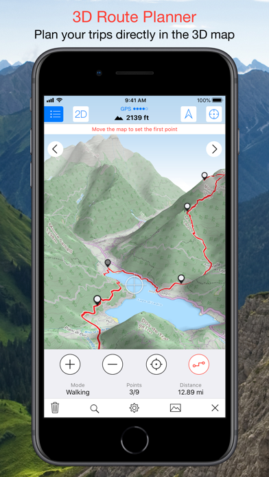
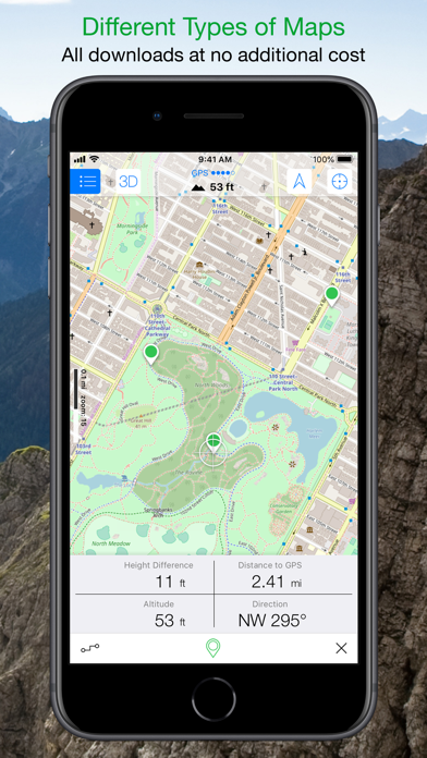
Enjoy exploring the great outdoors? If you’re a fan of biking, hiking and running then Maps 3D is the ideal app designed for planning your outdoor adventures. Whereas other mapping apps are primarily designed for cities and roads, displaying hills and mountains as flat and lifeless features, Maps 3D is packed with amazing features that brings the great outdoors to vibrant life with valleys, hills, mountains and footpaths displaying in full 3D so you’ll know your exact elevation. *** Featured by Apple with a main banner in the US App Store Navigation category! (02/2013) *** 3rd place at the '2013 Best App Ever Awards' by 148apps.com in 'Best Outdoors Apps' *** Over 1,700,000 global users! *** TOP 1 App in Navigation in 75+ countries (as of 01/2017) *** "The functions are helpful; the compilation of 3D maps is impressive." Macwelt.de – Score: 1.8 *** "An app recommended for hikers, cyclists and horse enthusiasts..." iPhone & iPad apps in Test Magazine, issue 3/2011 – Score: 8/10 STORE ROUTES & USE OFFLINE With Maps 3D you’ll have the option to plan, record and share your routes, turning your iPhone into a fully-fledged GPS device so you can log key coordinates and elevations. You’ll also have offline access to worldwide 3D map data which limits the drain on the battery and means that you can pre-load maps to store when you don’t have a signal. SEARCHABLE MAPS As an added bonus Maps 3D offers 3D terrain and trip planning, so you’ll never need to worry about getting lost. Towns, streets, mountain peaks and lakes are all searchable, with an accurate and precise map display based on NASA scans of the Earth’s surface combined with the outdoor map OSM (Open Street Map) and the Official USGS topo maps. LOAD YOUR TRIPS & SHARE GPX-tracks can be imported via iTunes, email, URL or Dropbox, and recorded tracks can be shared via email, Facebook and Twitter, great for showing your friends your latest outdoor accomplishments. MORE FEATURES +++ Load maps in advance over WIFI or 4G before your trek, no internet connection needed thereafter +++ Record your routes by GPS, all coordinates and exact elevations are logged +++ Plan and evaluate routes directly in the 3D map view +++ Search for towns, streets , mountain peaks, lakes - offline +++ Distance traveled, current and average speeds all displayed for an ideal trek GENERAL / NOTES Background GPS recording can significantly cut battery life * * * * * If you like Maps 3D, please remember to leave a positive rating on iTunes! The movingworld team is working constantly to improve Maps 3D. Any suggestions? We'd love to hear them! Just e-mail them to us at support@movingworld.de. We'll try to answer you within 24 hours! Thank you for using Maps 3D!
새로운 소식
– Improvements to the online router – Minor bug fixes and improvements * * * * * If you’d like to support us, please take a minute to update your review for this new version too. Positive reviews in iTunes enable us to continue producing further free updates like this one! The movingworld team is working constantly to improve Maps 3D. Any questions or suggestions for improvement? We'd love to hear them! Just e-mail them to us at support@movingworld.de. Thank you for using Maps 3D!
상세 정보
- 개발사
- movingworld GmbH
- 주 카테고리
- Navigation
- 현재 버전
- 6.8
- 버전 출시일
- 2024-05-06
- 최초 출시일
- 2011-03-25
- 용량
- 25 MB
- 연령 등급
- 4+
- 가격
- USD 3.99
- 언어
- NL, EN, FR, DE, IT, ES
- 번들 ID
- com.movingworld.geoguide3d
- 현재 버전 평점
- ★ 4.39 (204)
- 첫 수집
- 2026-05-28
메타데이터 갱신 2026-07-19
순위 히스토리
무료 기준 · 최대 90일 · 상위 5개 카테고리 표시 (Y축: 순위, 낮을수록 상위)
순위 히스토리 데이터가 없습니다
무료 순위
순위 없음
유료 순위
순위 없음
유저 리뷰
Clear and easy to see topography and no baloney. Great app
For some reason map data is randomly lost. The map name will show in the map list but data is gone, 0.0 mb, meaning you might be in the middle of nowhere and find you have no map to navigate with. Lesson learned.
Great hiking map. Simple to use with all the hiking data I want. Track, distance, speed, and a chart of the elevation changes of the recorded tracks. Low battery use, downloadable maps and no data collection. Hits every point for me. Thanks for such a useful app.
No fluff or bloat here. Does what it should do and nothing else. Best mapping and navigation app on the market. However, your email server seems to be misconfigured. I tried email both your addresses but they bounced back.
I’ve used this and its predecessors since at least 2015. I like it a lot. Sometimes it is a bit confusing, but it does just about everything. I would like to be able to save all tracks automatically to iCloud so I can see the tracks I record with my iPhone and Apple Watch on my iPad. Now I have to save each track individually and each one takes three or four taps. Making it automatic would be very nice. I would also like to have a way to put two tracks side by side on a map so I can compare how a trail has been changed over time. Or a way to load tracks onto Apple Maps. Maybe via a MacBook. I will have to fiddle with that. I appreciate that the earlier maps 3d app is still being updated but on my devices you can’t tell which is which other than to remember that one icon is blue on white and the other is white on blue. When managing apps it is confusing. Another cool thing would be to have it talk to Apple’s workout app the way that Strava does. I’d like to get away from strava.
Lots of downloadable maps with tons of details, doesn’t use much battery when tracking. I’ve had this app for years and used on tons of hikes. Interface takes a little time to understand but once you’re familiar it’s stellar. Highly recommend
I’ve tried many apps for using GPS while on long hikes. This one always works well. It’s worked well for years and years. Thanks to the people who make it for making something great.
I have used this app for trail riding all over the PNW. Easy to use, low battery use, reliable. I have a treasure trove of saved tracks. Love this app! “If you know the trails you will always have a friend to go with you.”
Probably the best 3D outdoors map app for the price. I always download a map before my hikes and they are a great help for any overgrown trails or wilderness areas with minimal markings. I have used this trail many times to help navigate old abandoned trails. The various types of maps make it easy to choose which one is best for your need. Friends always ask what is that cool app on your phone. Maps3D is a must have for the outdoor enthusiast.
Used free for a year, was great. Paid for pro. This week on casual day hike, loaded the app and received error reporting that the map data server was down. Still no map data. Had to reselect default map provider. This is link in white border at bottom of window of saved maps. 5 stars for great app, -1 star for UI / error handling.
山の状況など3Dでとても分かりやすい 日本語対応だともっと良いのですが 是非日本語対応お願いします
日本語化お願いします‼︎
변동(신규 진입·급상승) 감지된 앱에 한해 Apple RSS 최신 리뷰를 수집합니다.