

스크린샷


설명
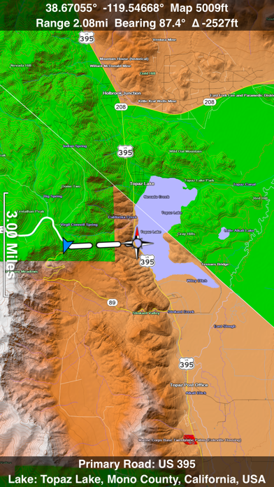
A 3D topo map of the Western USA and Hawaii. The vector map data is contained within the app and can be used without an internet connection. Use it in a car, a boat, a plane or while hiking. It is like having more than a third of the country in your pocket. Scenic Map now covers the entire world via online maps. The maps are cached automatically so they can still be used when there is no cell coverage. Turn on Online Map in the Settings menu and you can then scroll or go to any location on the planet. Satellite image overlays add breathtaking detail and realism to the maps (tap preset 2 or 4 when Online Map is enabled). You can use them as you travel to see what is hidden from view at ground level. This takes moving maps to a whole new level. Use the two finger vertical swipe gesture to tilt the map for a 3D view. Scroll like a map or fly like a flight simulator. Enable Joystick Gestures in the Settings menu and then fly around the terrain using a virtual joystick. Prefer only 2D maps? Enable the 2D Map option in the Settings menu. Scenic Map is simply the best 3D topo map available for a mobile device. You will see incredible detail while scrolling, rotating and zooming perfectly smoothly. You will see every road even if you zoom out to the altitude of a satellite. As you zoom in, you will see every small bump and hollow of the Earth and terrain features as small as ten meters. Unlike old fashioned topo maps, Scenic Map’s roads and trails are up to date thanks to OpenStreetMap.org. It contains polygons for urban areas, shopping malls, an ever growing number of buildings and many other features, The best lake, pond, stream and rivers from the USGS and Canadian public databases are also included. Tap the GPS center button to begin tracking your location. As you move, you will generate a track file. Tracks can be replayed with video like controls to speed up, slow down, pause, restart or skip to the end. You can display existing tracks while recording another if you want to retrace your route. When online, you can automatically create a route from your current GPS location to any other point on the map. Tracks can be received from or sent to other apps in GPX format. GPS recording stops automatically after you have remained stationary for some time or you can choose to manually stop tracking by tapping on the top track in the Tracks view. Never before have maps been this customizable. For example, you can turn on or off the roads. You can change the lighting direction or remove terrain shading entirely. You can display contour lines even over satellite images. There are five presets which let you quickly switch between map styles. Use Metric, English or Nautical units and choose one of four different coordinate displays including UTM. Want to learn more about a map feature? Tap the target icon and center the feature under the compass rose to display its name, type, urban area, county, state, elevation and coordinates. You will also see a bearing line back to your current GPS location or from your location to a selected waypoint. The status bar shows the bearing direction and distance along with the map and GPS elevation, the track length, and your current speed and direction of travel. In-app documentation is provided in the Help section at the top of the Settings menu. Links are provided in the documentation to detailed coverage maps, tutorial videos, installation guide and blog at ScenicMap.com Map data © OpenStreetMap and contributors under the Open Database License Scenic Map supports GPS tracking while the app is in the background. Caution: Continued use of GPS running in the background can dramatically decrease battery life.
새로운 소식
Fast initial download. Maps are then dowloaded automatically. Fixed track recording in iOS 17. Fixed the settings menu in landscape mode on iPhone. Fixed low frame rate when the information bar is enabled. The map's highest detail is now displayed while scrolling.
상세 정보
- 개발사
- GrangerFX
- 주 카테고리
- Navigation
- 현재 버전
- 1.9.2
- 버전 출시일
- 2024-01-19
- 최초 출시일
- 2010-04-01
- 용량
- 68 MB
- 연령 등급
- 4+
- 가격
- USD 4.99
- 언어
- EN
- 번들 ID
- com.grangerfx.scenicmapw
- 현재 버전 평점
- ★ 4.23 (13)
- 첫 수집
- 2026-06-11
메타데이터 갱신 2026-07-16
순위 히스토리
무료 기준 · 최대 90일 · 상위 5개 카테고리 표시 (Y축: 순위, 낮을수록 상위)
순위 히스토리 데이터가 없습니다
무료 순위
순위 없음
유료 순위
순위 없음
이 개발사의 다른 앱


유저 리뷰
I’ve owned this app for probably 10 years now. I haven’t compared it to competing apps that have come out since, but with no sub and the entire bundle for $30, I’ve definitely more than gotten my money’s worth. Years ago, I turned a corner on a new trail. I encountered unexpected (although not actually surprising) snow drifts covering the trail. Someone was coming out with snowshoes and told me she’d spent a long time and couldn’t find the lake. I got out this app, and got to enjoy a nice afternoon at a gorgeous lake.
A friend showed me Scenic Map years ago and it is still my go-to mapping app. I used it to navigate during a weeklong trip backpacking in Alaska way off the beaten path and it performed like a champ. Thanks for continuing to support this amazing app!
Love It! Works Great…Must Have when no Cell Service.
A topo app you can use offline? What more could an outdoorsman want. I only give it 4/5 stars just because no one believes that 5/5 star reviews are authentic. I love this app and use it all the time in the back country where there’s no cell or wifi. Keep up the great work!
I’ve used this for years to navigate the mountains and canyons of the Western US. It is the most reliable, complete OFFLINE map I’ve found. It’s imaging and shading are very useful for getting a sense of the terrain, vegetation, and even where sunlight is hitting. The limitations are that the dirt road and trail accuracy is decent, but not great. Eg here in Idaho there are old roads that traverse private property or are defunct, still shown here. However, this isn’t alone in that problem, most other maps have the same issue. The good news is that this also includes some roads and trails that the other major maps are missing. The user interface is a bit unusual at first, but once used to it, it is powerful. I always keep a copy of this on my devices, you never know when the zombie apocalypse will knock out the internet (or maybe you just go out of cell range).
I love the fact it does not need cell coverage to work. I can be in the middle of no where and have this thing show me my location. Far to many people get into the hills and get lost. Then cant even tell the SAR team their location. This turns my cellphone into a mapping GPS without cell coverage. I love it. But know this app is big. Still loving it! 9 June 2019 I have used it deep canyons and it still works.
Way to slow rendering maps. Pyrolysis needs work
This app is easily the best I've used of its type. I use it routinely when backcountry skiing and hiking in the western United States. It is my first choice when planning tours and making adjustments on route. The maps are excellent, clear and well detailed and the UI is intuitive. No need to download maps is great. I discovered it also includes Hawaii which was an unexpected pleasure. Everything you want, nothing you don't. 5/5
Low on detail compared to eastern version and other poducts
Are you kidding me!? 90% of Colorado and New Mexico are missing from the Western USA map!! So now I'll have to buy two different maps and spend twice as much just to see what should already be included in this OVER PRICED app? It's hard to navigate and does not work as smoothly as most other map apps. Deleted !
변동(신규 진입·급상승) 감지된 앱에 한해 Apple RSS 최신 리뷰를 수집합니다.