
스크린샷

설명
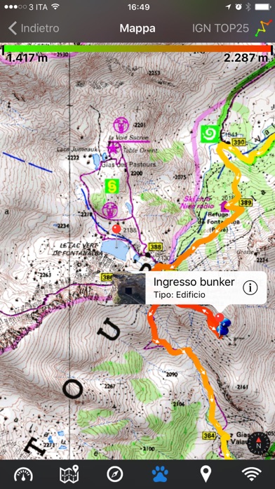
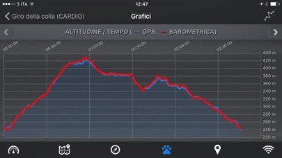
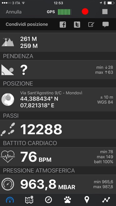
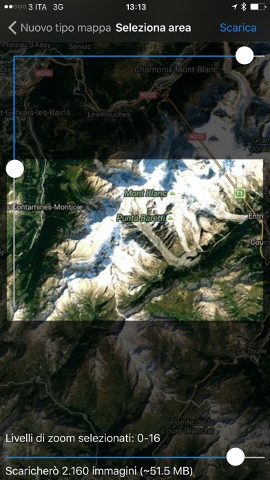
EasyTrails GPS is the GPS tracker application for your iPhone. The perfect application for those who are passionate about OUTDOOR ACTIVITIES and TRAVELING, everybody who likes outdoor sports, and not only. Are you going for a bike or motorcycle ride? Well, EasyTrails GPS will tell you how many miles you traveled, how much time you spent, how high you climbed and many other details. In real-time it will show you the course on a map, comparing it with downloaded tracks and points of interest. You can import or share all tracks and waypoints, photos and ideas for new journeys with your friends. Share where you are on Facebook and Twitter through your GPS position, and export your tracks in standard formats, so you can review them on Google Earth, SportTracks and TrailsRunner. Or simply upload them to online services like Garmin Connect, or many others. It's possible to import tracks by e-mail or Safari (EasyTrails can handle GPX, KML/KMZ and ZIP file formats), or by wi-fi networks, using an improved and easy to use web-based sharing feature. Calculate routes and let EasyTrails guide you using the new navigation capabilities. You can also let it guide you through previously recorded tracks. Additionally, EasyTrails GPS can communicate with navigators like Maps, Google Maps, TomTom or Waze (if installed) for more advanced guidance needs. Load custom cartography, EasyTrails supports KMZ and MBTILES formats. EasyTrails GPS is easy to use and extremaly accurate. It ensures the maximum duration of battery thanks to the possibility of recording in "StandBy" mode. However, be aware that use of GPS, even in background, will have a significant impact on battery duration. ► For more info, visit our website: www.easytrailsgps.com NEW FEATURES: ► Heart rate monitoring (paid) We added the ability to connect to compatible Bluetooth heart rate monitors (such as Polar H6 and H7 devices). Heart rate can be seen in real time from the dashboard. With the 'Heart rate monitoring' in-app purchase: - heart rate data will be associated to GPS tracks - saved tracks will have an extra heart rate chart - heart rate data will be saved to HealthKit Additionally, with the 'Colored tracks' in-app purchase, it will be possible to highlight heart rate data directly on the map screen of a recorded track. OTHER FEATURES: - Support for many different map types - Support for different coordinate systems - Support for user-loaded offline cartography (KMZ and MBTILES) - Export tracks (single or multiple) in standard formats (GPX, KML/KMZ and CSV), with their associated waypoints and pictures - Import tracks (GPX and KML/KMZ) - Import waypoints (GPX and KML/KMZ) - Resume recording of tracks - Save waypoints with photos and descriptions - Navigate to a point of interest - Sharing via Facebook and Twitter - Follow a path/track - Navigate (distance / direction) towards any waypoint - Navigate (distance / direction) towards any track marker (start / pause / resume / end points) - Advanced Navigation to a waypoint using any navigation app you may have installed - Upload tracks to GPSies (http://www.gpsies.com) - Upload tracks to SportTracks (http://sporttracks.mobi) - Upload tracks to OpenTrail (http://www.opentrail.us) - Upload tracks to OkMap (http://www.okmap.org) - Real-time visualization of distance, speed, altitude bearing and other data - Map Visualization in different modes: street map, satellite, hybrid, terrain - Charts (elevation profiles, ...) - Digital Compass - Heart rate monitoring - Turn by turn directions - High battery duration (record in standby) - Select between metric, imperial and nautical measuring systems - Intuitive and User Friendly interface - Lightweight, reliable and accurate - Doesn't require internet connection Terms of Use: https://www.apple.com/legal/internet-services/itunes/dev/stdeula/ Privacy Policy: http://www.easytrailsgps.com/wp-content/uploads/2016/05/EasyTrails-GPS-Privacy-Policy.pdf
새로운 소식
Improved compatibility with new device screen sizes
상세 정보
- 개발사
- Zirak s.r.l.
- 주 카테고리
- Sports
- 현재 버전
- 11.9
- 버전 출시일
- 2025-04-17
- 최초 출시일
- 2009-08-14
- 용량
- 30 MB
- 연령 등급
- 4+
- 가격
- USD 3.99
- 언어
- NL, EN, FR, DE, IT, PT 외 4
- 번들 ID
- com.zirak.easytrails
- 현재 버전 평점
- ★ 4.61 (254)
- 첫 수집
- 2026-05-28
메타데이터 갱신 2026-07-19
순위 히스토리
무료 기준 · 최대 90일 · 상위 5개 카테고리 표시 (Y축: 순위, 낮을수록 상위)
순위 히스토리 데이터가 없습니다
무료 순위
순위 없음
유료 순위
순위 없음
유저 리뷰
This was my favorite go to app over all the apps I ever used, but then last year they would never update my information to let me use my watch, and it kept saying that I had to buy the subscription which I had already bought. Every time I would click by it would say I’d already purchased it, but it still said I didn’t own it. I tried to contact the nonexistent tech-support and I finally gave up and just started using Garman. If they ever fix it, I would love to go back to
Had this app since 2007 I think. Been great for so many trips.
I use Easy Trails to track my trail riding mileage. It's simple to use and functions when I don't have cell service. I occasionally forget to turn it off when we stop for lunch or I’m finished riding. It would be nice to have an option to edit the track.
Thumbs up…get it if you trail ride. Makes finding your way home a breeze…LOVE THE PRICE
So what? I do not care. Since my last iPhone iOS update this message is said out loud to me several times while the tracker is active. What does it matter? Access, or not, to barometer data matters not to me. I would like to disable this requirement & spoken message.
Love the app, just wish there was a way to retrieve my info when it somehow accidentally got deleted
I have used Easy Trails to track my trail riding mileage for several years. It’s simple to use and functions even when I don’t have cell service. It’s also super easy to export tracks to TopTrail. It would be great if I had the ability to edit a track when I occasionally forget to turn it off when I am done riding, but otherwise I love it.
This app is difficult to use and it does NOT have anyone to help when you have a problem. Dislike this sort of Junk!
It’s great it’s keeps up with the miles I drive my team of mules
This app has delivered from local trail to the Big South Fork! Thank you! Vicky Rhein
변동(신규 진입·급상승) 감지된 앱에 한해 Apple RSS 최신 리뷰를 수집합니다.