
스크린샷


설명
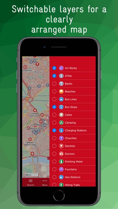
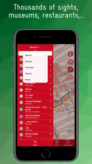
Customisable offline map from Openstreetmap with contour lines in which even the smallest paths and trails are shown. POIs are grouped into categories and can be displayed as layers. For example, you can display all restaurants, public transport lines, banks, hiking trails, charging stations and doctors on the map. The size and overlap of the icons can be adjusted to improve clarity. An integrated database allows you to search for POIs as well as a large number of streets, towns, villages, districts, etc. The search can be filtered by category and/or distance. For many POIs there is further information such as opening hours, address, disabled access, ... Notes or favourites can be created for each POI, a history list shows the most recently used POIs, content can be shared. A location function shows the current position, the app is ad-free and there is no tracking.
새로운 소식
Troubleshooting: – Contour lines are visible again
상세 정보
- 개발사
- Joerg Holz
- 주 카테고리
- Travel
- 현재 버전
- 3.2.1
- 버전 출시일
- 2024-03-18
- 최초 출시일
- 2019-06-05
- 용량
- 254 MB
- 연령 등급
- 4+
- 가격
- USD 3.99
- 언어
- EN, DE
- 번들 ID
- com.workflowmanagement.london
- 현재 버전 평점
- ★ 0.00 (0)
- 첫 수집
- 2026-06-09
메타데이터 갱신 2026-06-09
순위 히스토리
무료 기준 · 최대 90일 · 상위 5개 카테고리 표시 (Y축: 순위, 낮을수록 상위)
순위 히스토리 데이터가 없습니다
무료 순위
순위 없음
유료 순위
순위 없음