스크린샷

설명
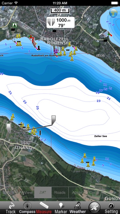
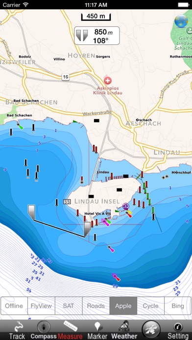
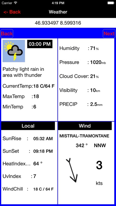
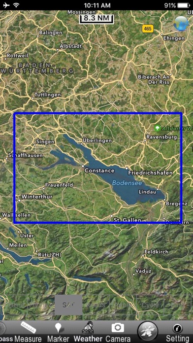
Flytomap is a valid and interesting alternative, Benetti Yachts Top Ten 2011,2012,2013,2014,2015 & 2016 Featured in : On the Deck Constance coverage resident in the app. It works WITHOUT mobile coverage! Worldwide Marine and Outdoor Maps available when connected, thanks to viewer.flytomap.com Worldwide Satellite images overlay on charts Worldwide Terrain features overlay on charts, thanks to Open Street Map, Open Cycle Map, Bing,Earth,GMap Worldwide Weather forecast Use to Explore: √ Latitudes and Longitudes to go to your favorite places √ Search your Favorite points directly √ Zoom, Rotate and Pan fast just by a finger touch √ Quick Object information just tapping, thanks to vector technology √ GPS Heading Vector Towards the direction movement √ Distance Measurement Tool to easily calculate the distance from one location to another √ Route planning, Waypoints - Insert the target/destination and see in real time your speed, distance and bearing √ Magnified Lens for all info √ Unlimited Tracks, Markers, Geo-tagged photos, records and share via email, visible on Google, Flytomap Viewer, KMZ format - Store your track without the need of cellular data or mobile signal √ Select Depth Contours √ a la carte menu √ iOS background mode - Flytomap works in background as well, you can swap with another app and receive/make calls send sms while track recording. √ Optimized battery usage √ Worldwide Marine Weather forecast at a quick tap provide you: • Day max and min temperature - Current temperature • Significant wave height, Swell height, Swell period, Swell direction • Tide data • Sea temperature • Wind Speed and direction • Weather description • Precipitation & Humidity • Visibility • Pressure • Cloud cover in percentage • Wind chill/Feels like Temperature • Water Temperature • Dew Point Temperature • Heat Index Temperature √ And so much more to come - It’s the only app you will ever need! Our charts are installed on: GARMIN NAVICO LOWRANCE B&G NORTHSTAR EAGLE SIMRAD Follow us: ▶Twitter @flytomap ▶Web Site flytomap.com ▶Web App viewer.flytomap.com ▶Facebook facebook.com/flytomap Flytomap is committed to constant improvement, this App is developed with the help of professional boaters to get the best experience on the sea, we listen to our users and systematically add the most requested features. Thank you for the feedback! "Continued use of GPS running in the background can dramatically decrease battery life."
새로운 소식
This update from Apple will improve the functionality of this app. No new features are included.
상세 정보
- 개발사
- Flytomap
- 주 카테고리
- Navigation
- 현재 버전
- 1.0
- 버전 출시일
- 2016-06-16
- 최초 출시일
- 2016-06-16
- 용량
- 130 MB
- 연령 등급
- 4+
- 가격
- USD 2.99
- 언어
- EN, FR, IT, ES
- 번들 ID
- com.flytomap.LMConstance
- 현재 버전 평점
- ★ 1.00 (1)
- 첫 수집
- 2026-05-30
메타데이터 갱신 2026-07-09
순위 히스토리
무료 기준 · 최대 90일 · 상위 5개 카테고리 표시 (Y축: 순위, 낮을수록 상위)
순위 히스토리 데이터가 없습니다
무료 순위
순위 없음
유료 순위
순위 없음
이 개발사의 다른 앱
유저 리뷰
I bought this app for offline use while biking around Lake Constance, however on my iPhone I could not get offline to work. I had a blank grey screen with a location dot. Not helpful.
변동(신규 진입·급상승) 감지된 앱에 한해 Apple RSS 최신 리뷰를 수집합니다.