
스크린샷
설명
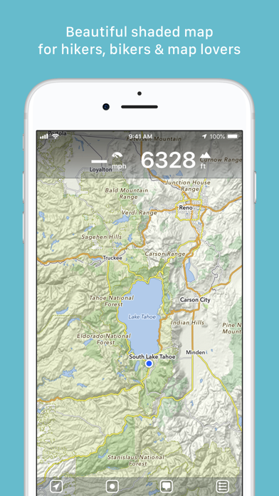
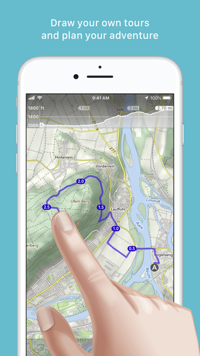
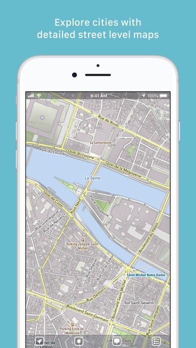
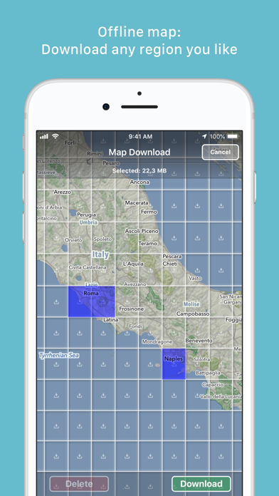
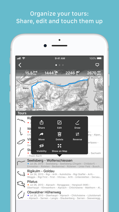
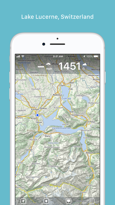
“MapOut saves the day with its intuitive interface for drawing routes and viewing elevation profiles. I’m genuinely impressed by its powerful features!” – Alee, cyclingabout.com Offline maps covering the entire globe, optimized for iPhone and iPad. As beautiful as a traditional paper map—but far more versatile. Perfectly tailored for: - Hikers: Clear, detailed terrain maps accessible even in the most remote locations, without an internet connection. - Cyclists: Extensive cycling route network with real-time speed and distance tracking. - City Travelers: Detailed city maps complete with essential tourist information. - Map Enthusiasts: Simply elegant maps that are a pleasure to view. Innovative 3D Tilt View - Tilt your device in any direction to vividly explore terrain details. Learn more at [mapout.app](https://mapout.app). Powerful Offline Search - Easily find places, streets, mountains, and more—no internet needed. High-Quality Map Data - Built upon the OpenStreetMap project, the "Wikipedia of Maps". Contribute your own corrections and additions at OpenStreetMap.org. - Regularly updated offline maps available for your selected regions. Effortless Tour Planning - Draw: Easily create custom routes and waypoints directly on your map. Adjust existing tours or imported GPX files effortlessly. - Import: Transfer routes to your device via email using a free "MapOut.me" account. Discover countless GPX and KML route files online, ideal for hiking or biking (e.g., gpsies.com). - Record: Capture your adventures and easily share them with friends. - Insights: Quickly see vital information for every tour—distance, elevation changes, route profile, and map details. Superior Map Viewing Experience - Rapid, hardware-accelerated rendering for smooth navigation. - Continuous zoom with impeccable clarity at every level. - Detailed topographical views featuring contour lines and shading. - Versatile overlays include biking, hiking, skiing routes, sightseeing locations, and public transport networks. Find comprehensive support and answers in our user manual: https://mapout.app/manual Map data © OpenStreetMap contributors https://www.openstreetmap.org/copyright
새로운 소식
- fixed bug in dashboard
상세 정보
- 개발사
- Valnova
- 주 카테고리
- Navigation
- 현재 버전
- 3.4.13
- 버전 출시일
- 2025-05-27
- 최초 출시일
- 2012-03-20
- 용량
- 71 MB
- 연령 등급
- 4+
- 가격
- USD 4.99
- 언어
- EN, FR, DE
- 번들 ID
- ch.valnova.MapOut
- 현재 버전 평점
- ★ 4.91 (137)
- 첫 수집
- 2026-05-28
메타데이터 갱신 2026-07-19
순위 히스토리
무료 기준 · 최대 90일 · 상위 5개 카테고리 표시 (Y축: 순위, 낮을수록 상위)
순위 히스토리 데이터가 없습니다
무료 순위
순위 없음
유료 순위
경쟁 벤치마크 — Navigation Top 10
이 앱을 이기려면 무엇이 필요한가 — 같은 카테고리 상위권과의 비교입니다. 주황색 행이 현재 앱입니다.
| # | 앱 | 가격 | 평점 | 리뷰 수 | 언어 | 최근 업데이트 |
|---|---|---|---|---|---|---|
| 1 | MilGPS | USD 12.99 | ★ 4.83 | 5,506 | 1 | 2026-06-20 |
| 2 | Solocator - GPS Field Camera | USD 0.99 | ★ 4.27 | 413 | 1 | 2026-04-04 |
| 3 | Land Nav Assistant | USD 2.99 | ★ 4.48 | 73 | 1 | 2019-04-08 |
| 4 | Blitzer.de PRO | USD 0.49 | ★ 4.33 | 21 | 11 | 2026-06-30 |
| 5 | Sun Seeker - Sunlight Tracker | USD 11.99 | ★ 4.84 | 12,794 | 5 | 2026-07-10 |
| 6 | Sporty's E6B Flight Computer | USD 9.99 | ★ 4.90 | 5,287 | 1 | 2024-02-17 |
| 7 | Exit Strategy NYC Subway Map | USD 3.99 | ★ 4.76 | 187 | 1 | 2026-07-16 |
| 8 | Omaha Zoo - ZooMap | USD 0.99 | ★ 1.35 | 46 | 1 | 2023-09-11 |
| 9 | Find93 | USD 4.99 | ★ 3.67 | 18 | 1 | 2026-04-14 |
| 10 | Speedometer 55 Pro. GPS kit. | USD 3.99 | ★ 4.71 | 2,715 | 11 | 2026-07-05 |
| 26 | MapOut | USD 4.99 | ★ 4.91 | 137 | 3 | 2025-05-27 |
유저 리뷰
地図が綺麗で見やすい。 メインスマホと古いスマホ(ios6)で使ってます。 バージョンが新しい方はルートを作成できていいのですが、ダブルタップでズームインとズームアウトをする時、古いバージョン(ios6)みたいににどこでタップしても中心を軸にズームインとズームアウトをするようにできるともっと使いやすいと思う。 改善希望です。
I love this app for hiking and such, I just wish there was a dark mode.
This app got me through a year and a half of motorcycling through Latin America. I was recommended it by a bicyclist on a similar trip, and now I recommend it to everyone I can!
Map out doesn’t drain the battery rapidly like other navigation programs awesome app
I am so happy to have purchased this app. It is the most perfect hiking/biking mapping app i’ve found. No subscriptions. Great Offline support. It has everything you need and nothing you don’t.
This is just what I was looking for, planning scout hikes is so much easier and encourages the kids to use navigation on paper maps.
I love this app… it’s my goto route planning software as it is so intuitive to use. I mainly use it to plan bicycle routes and to some extent motorcycle routes. I would love to see a car/motorcycle route option that would keep me on the main roads rather than divert me on to side roads. Thanks again for a great product.
Great app for building hiking, biking or off-road motorcycle routes. Intuitive and easy to learn. Love it!
I always use MapOut for planning for hiking routes. It's great at showing all the hiking trails and the recommended hiking routes. Its elevation estimation is quite accurate. I sometimes consult books and other sources for hiking route suggestions and it's a breeze to create a tour in MapOut. A one-time purchase is so much better than other subscription-based apps since I only hike ~20 times per year. Using MapOut for cycling is a bit of a worse experience. Well for one road cyclists need paved roads, gravel cyclists can tolerate some unpaved roads, but I couldn't find a way for MapOut to differentiate these. That's why I had an unpleasant experience of planning a tour in advance, and then when I arrive there on a road bike I find it's only an unpaved trail. Also MapOut doesn't have turn-by-turn navigation or the ability to create a cue sheet. I can get rid of my cycling computer if you add navigation on the Apple Watch.
Why pay for pointless subscriptions like AllTrails for features you don’t even need and a glitchy, clunky app? I love that you buy this one time and it just has the functionality you need, with quick loading and easy area downloads. Used this app exclusively to navigate the sawtooth wilderness loop, glacier north circle, and Uinta Highline trails, as well as numerous shorter trips and day hikes. Truly excellent app.
While it takes some time to learn all the controls, this app makes my unplanned cycle tours so much easier! I draw routes into the app and export to the Coros app and then to my cycle computer. If I had one request, it would be to search for places by their icon. For example, search for water (water droplet) or camping sites (tent icon).
ウルトラマラソンのときに、予め決めたコースを走りたいときに使いやすかったです。機内モードにすればかなりの節電になりました。月末海外レースがあるので、現地のマップをダウンロードしました。別途地図代が付与なのも良いです。
변동(신규 진입·급상승) 감지된 앱에 한해 Apple RSS 최신 리뷰를 수집합니다.