
스크린샷


설명
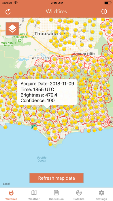
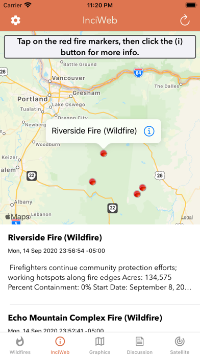
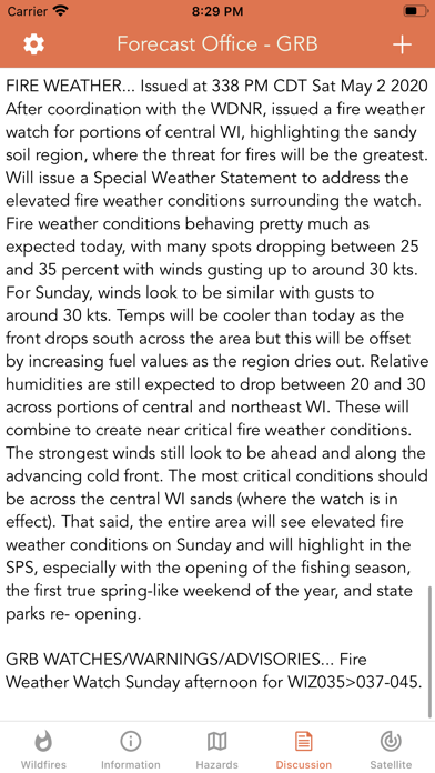
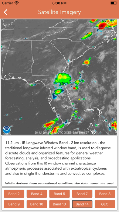
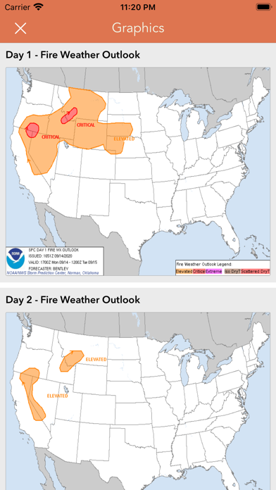
Download the most comprehensive Wildfire app for iOS. CURRENT WILDFIRES - MODIS Thermal Satellite Fire Detection - VIIRS IBAND Fire Detection - MODIS + VIIRS Spot Details - Fire Weather Outlook: Days 1 - 8 - Large Fire Points - Dry Thunderstorm Fire Weather Outlook - National Fire Incident Reports - Fire Potential Index: 7-day Forecast - Large Fire Probability - Fire Danger Rating - Expected Large Fires per PSA - National Significant Fire Outlook: 4-months - NFDRS Dead Fuel Moisture - US Drought Monitor & Index HAZARDOUS WILDFIRE CONDITION ZONES - Detailed NOAA discussion GOES-16 SATELLITE IMAGERY ANIMATIONS - Regional zones (CONUS) * Available for iPhone and iPad with single purchase * Feel free to contact me at mwnbdc@gmail.com if you have any questions. Enjoy.
새로운 소식
+ Updated GOES-East imagery to utilize GOES-19, the designated replacement for GOES-16 + Fixed a few minor bugs Thank you for the positive feedback!
상세 정보
- 개발사
- LW Brands, LLC
- 주 카테고리
- Weather
- 현재 버전
- 1.4
- 버전 출시일
- 2025-04-10
- 최초 출시일
- 2018-08-06
- 용량
- 9 MB
- 연령 등급
- 12+
- 가격
- USD 0.99
- 언어
- EN, FR, PT
- 번들 ID
- wildfires.lwbrandsllc
- 현재 버전 평점
- ★ 4.41 (1,713)
- 첫 수집
- 2026-05-28
메타데이터 갱신 2026-07-19
순위 히스토리
무료 기준 · 최대 90일 · 상위 5개 카테고리 표시 (Y축: 순위, 낮을수록 상위)
순위 히스토리 데이터가 없습니다
무료 순위
순위 없음
유료 순위
경쟁 벤치마크 — Weather Top 10
이 앱을 이기려면 무엇이 필요한가 — 같은 카테고리 상위권과의 비교입니다. 주황색 행이 현재 앱입니다.
| # | 앱 | 가격 | 평점 | 리뷰 수 | 언어 | 최근 업데이트 |
|---|---|---|---|---|---|---|
| 1 | RadarScope | USD 9.99 | ★ 4.17 | 2,707 | 4 | 2026-07-01 |
| 2 | My Lightning Tracker Pro | USD 4.99 | ★ 4.81 | 5,895 | 12 | 2026-06-25 |
| 3 | MyRadar Weather Radar Pro | USD 5.99 | ★ 4.84 | 42,706 | 9 | 2026-07-14 |
| 4 | My Earthquake Alerts Pro | USD 2.99 | ★ 4.77 | 5,805 | 7 | 2026-06-25 |
| 5 | RadarOmega: Doppler Radar App | USD 8.99 | ★ 3.53 | 896 | 1 | 2026-07-15 |
| 6 | Foggy: Bay Area Fog Tracker | USD 5.99 | ★ 5.00 | 15 | 1 | 2026-07-09 |
| 7 | NOAA Weather Radio | USD 4.99 | ★ 4.25 | 9,619 | 1 | 2026-07-08 |
| 8 | RainAware | USD 4.99 | ★ 3.92 | 1,065 | 1 | 2026-05-22 |
| 9 | Earthquake Network | USD 1.99 | ★ 4.56 | 2,086 | 9 | 2026-04-03 |
| 10 | River Levels & Flows | USD 2.99 | ★ 4.60 | 2,620 | 3 | 2026-06-11 |
| 14 | Wildfire - Fire Map Info | USD 0.99 | ★ 4.41 | 1,713 | 3 | 2025-04-10 |
이 개발사의 다른 앱
National Hurricane Center Data
Weather · ★ 4.8 (74,950)
Marine Weather Forecast Pro
Weather · ★ 4.7 (16,023)
NOAA Marine Forecast & Weather
Weather · ★ 4.7 (4,907)
Nautical Charts & Maps
Navigation · ★ 4.6 (3,768)
Topographic Maps & Trails
Navigation · ★ 4.6 (2,810)
River Levels & Flows
Weather · ★ 4.6 (2,620)
Great Lakes Boating Weather
Weather · ★ 4.6 (1,408)
Topo Map & Hiking Tracker
Navigation · ★ 4.7 (1,357)
유저 리뷰
I’m in SE GA with a large wildfire about 10 miles away from me right now. At the moment it seems to be moving away. I like your map, but have a couple questions: 1. What’s the difference between the orange and yellow dots? There is no legend. 2. Can you incorporate wind direction and speed? It would be great to have a visualization of both in relation to the location of the wildfires. Thanks for providing your app.
Title pretty much says it all. I just paid .99 for an app that is supposed to show wildfires and it doesn’t show the largest one currently burning the you-know-what out of SoCal. The fact that I can see it when I look to my southwest is helpful, but I’d love to know if my recently evacuated house is among the 27k acres it has burned. Yes, I know that there are reasons the app might not show various fires blah blah blah, but this is inexcusable.
Worthless for this
Thanks for continual update on point fire and all othrts
Until last summer (2023), this was the only fire-reporting app I had or needed. But in the aftermath of the wildfires in ON & QC and their severe downwind effects in the Eastern US, this app is now effectively sidelined because of the lack of coverage of Canada. I’ll be using another that does have this coverage, which tells me that the data are readily available and that the dev just needs to incorporate them. I hope that will happen, at which point I would gladly change my review to 5*s. I have two of the dev’s other apps — Snow Report and River Levels — which are great. I expect this would be as well with inclusion of Canada. 🇨🇦
Clicking on the inciweb tab makes the whole app shut down. Fire data does not appear to be updating. I’ve contacted the developer with no responses correcting the issues. I have noticed that all of the feedback is from a year or more ago. Edit 8/8/23: thanks for the correction. The app is working fine now, and the link to Inciweb is seamless and works nicely.
I tapped on every possible setting and layer (of which there are few to none) to set it up, and the fires currently burning are not even showing… the settings gears just links me to other apps this company offers. The informational maps cannot be drilled down into - they literally look like placeholders with nominal graphics. I cannot understand why the developer believes that their app is functional because appears to be a skeleton with nothing fleshing it out in a live interactive manner. Please don’t tell me I need to update the version, as I just downloaded it an hour ago. Utter facepalm. Deleting. You got my dollar.
For me. This app was a bust. I needed updates on a local fire and it lagged well behind info from open sites on the web. I went elsewhere to get updates. Might be good for some but for me? Just didn’t work. Sorry folks.
I live in California, app always starts in Australia. We had nearby fire that was not identified. Would not rely on this app as my “go to”. Developer was kind enough to point out that I was running an older version. Update version took care of the problem and added nice features. The ability to move to incident feeds is especially nice. ThNk you
Good technically based analysis - had to get definitions for a few weather abbreviations. I expected to see a few active NorCal fires showing on map, but did not. Maybe they’re no longer burning? Or maybe I need to learn to use this app.
변동(신규 진입·급상승) 감지된 앱에 한해 Apple RSS 최신 리뷰를 수집합니다.